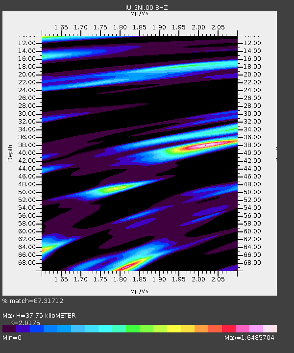
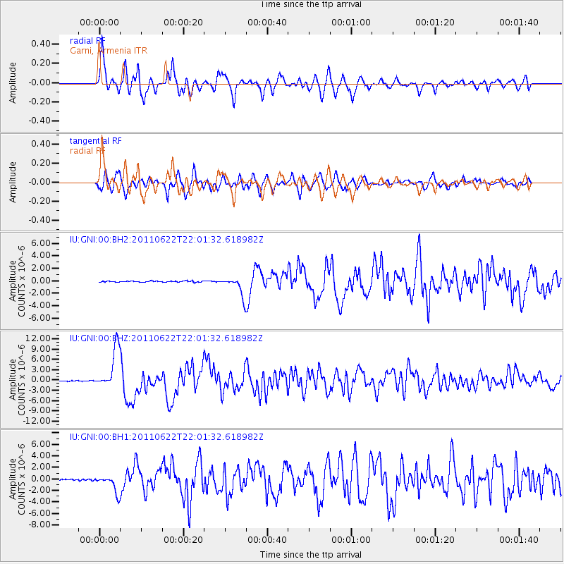
GNI Garni, Armenia - Earthquake Result Viewer

Earthquake location: Near East Coast Of Honshu, Japan
Earthquake latitude/longitude: 40.0/142.2
Earthquake time(UTC): 2011/06/22 (173) 21:50:52 GMT
Earthquake Depth: 33 km
Earthquake Magnitude: 6.7 MW, 6.1 MB, 6.7 MW, 6.7 MS
Earthquake Catalog/Contributor: NEIC PDE/NEIC PDE-M
Network: IU Global Seismograph Network (GSN - IRIS/USGS)
Station: GNI Garni, Armenia
Lat/Lon: 40.15 N/44.74 E
Elevation: 1609 m
Distance: 70.5 deg
Az: 306.254 deg
Baz: 53.966 deg
Ray Param: 0.054910336
Estimated Moho Depth: 37.75 km
Estimated Crust Vp/Vs: 2.02
Assumed Crust Vp: 6.291 km/s
Estimated Crust Vs: 3.118 km/s
Estimated Crust Poisson's Ratio: 0.34
Radial Match: 87.31712 %
Radial Bump: 400
Transverse Match: 77.37468 %
Transverse Bump: 400
SOD ConfigId: 558545
Insert Time: 2013-09-18 20:24:41.714 +0000
GWidth: 2.5
Max Bumps: 400
Tol: 0.001

Signal To Noise

ChannelStoNSTALTA
IU:GNI:00:BHZ:20110622T22:01:32.618982Z69.496616.1234277E-68.8111165E-8
IU:GNI:00:BH1:20110622T22:01:32.618982Z18.9011671.5413935E-68.155018E-8
IU:GNI:00:BH2:20110622T22:01:32.618982Z17.980581.5978715E-68.886652E-8
Arrivals
Ps6.3 SECOND
PpPs18 SECOND
PsPs/PpSs24 SECOND