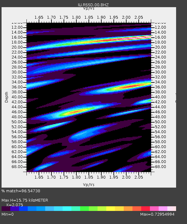
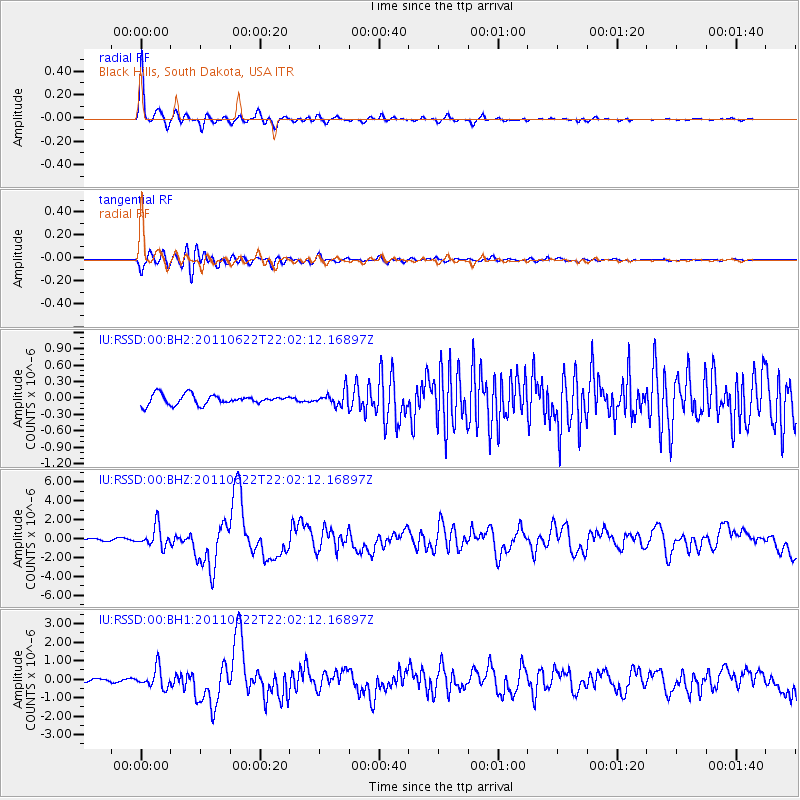
RSSD Black Hills, South Dakota, USA - Earthquake Result Viewer

Earthquake location: Near East Coast Of Honshu, Japan
Earthquake latitude/longitude: 40.0/142.2
Earthquake time(UTC): 2011/06/22 (173) 21:50:52 GMT
Earthquake Depth: 33 km
Earthquake Magnitude: 6.7 MW, 6.1 MB, 6.7 MW, 6.7 MS
Earthquake Catalog/Contributor: NEIC PDE/NEIC PDE-M
Network: IU Global Seismograph Network (GSN - IRIS/USGS)
Station: RSSD Black Hills, South Dakota, USA
Lat/Lon: 44.12 N/104.04 W
Elevation: 2090 m
Distance: 77.2 deg
Az: 42.519 deg
Baz: 313.837 deg
Ray Param: 0.05040478
Estimated Moho Depth: 15.75 km
Estimated Crust Vp/Vs: 2.08
Assumed Crust Vp: 6.242 km/s
Estimated Crust Vs: 3.008 km/s
Estimated Crust Poisson's Ratio: 0.35
Radial Match: 96.54738 %
Radial Bump: 313
Transverse Match: 89.037796 %
Transverse Bump: 400
SOD ConfigId: 558545
Insert Time: 2013-09-18 20:25:14.111 +0000
GWidth: 2.5
Max Bumps: 400
Tol: 0.001

Signal To Noise

ChannelStoNSTALTA
IU:RSSD:00:BHZ:20110622T22:02:12.16897Z12.6027491.0878456E-68.631812E-8
IU:RSSD:00:BH1:20110622T22:02:12.16897Z7.5410475.341809E-77.083644E-8
IU:RSSD:00:BH2:20110622T22:02:12.16897Z1.505161.3420463E-78.916303E-8
Arrivals
Ps2.8 SECOND
PpPs7.6 SECOND
PsPs/PpSs10 SECOND