You are here: Home > Network List > US - United States National Seismic Network Stations List
> Station AGMN Agassiz National Wildlife Refuge, Minnesota, USA > Earthquake Result Viewer
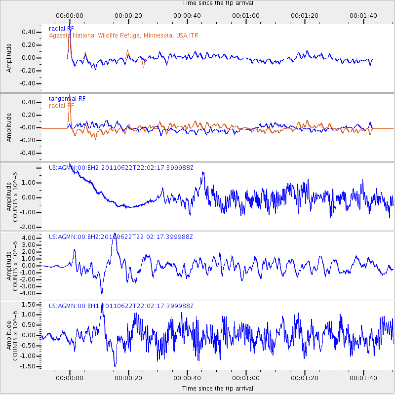
AGMN Agassiz National Wildlife Refuge, Minnesota, USA - Earthquake Result Viewer
*The percent match for this event was below the threshold and hence no stack was calculated.
| Earthquake location: |
Near East Coast Of Honshu, Japan |
| Earthquake latitude/longitude: |
40.0/142.2 |
| Earthquake time(UTC): |
2011/06/22 (173) 21:50:52 GMT |
| Earthquake Depth: |
33 km |
| Earthquake Magnitude: |
6.7 MW, 6.1 MB, 6.7 MW, 6.7 MS |
| Earthquake Catalog/Contributor: |
NEIC PDE/NEIC PDE-M |
|
| Network: |
US United States National Seismic Network |
| Station: |
AGMN Agassiz National Wildlife Refuge, Minnesota, USA |
| Lat/Lon: |
48.30 N/95.86 W |
| Elevation: |
351 m |
|
| Distance: |
78.2 deg |
| Az: |
35.377 deg |
| Baz: |
318.206 deg |
| Ray Param: |
$rayparam |
*The percent match for this event was below the threshold and hence was not used in the summary stack. |
|
| Radial Match: |
67.90359 % |
| Radial Bump: |
400 |
| Transverse Match: |
44.0709 % |
| Transverse Bump: |
400 |
| SOD ConfigId: |
558545 |
| Insert Time: |
2013-09-18 20:25:35.860 +0000 |
| GWidth: |
2.5 |
| Max Bumps: |
400 |
| Tol: |
0.001 |
|
Signal To Noise
| Channel | StoN | STA | LTA |
| US:AGMN:00:BHZ:20110622T22:02:17.399988Z | 10.660662 | 9.3160105E-7 | 8.7386795E-8 |
| US:AGMN:00:BH1:20110622T22:02:17.399988Z | 1.9208343 | 2.8701047E-7 | 1.4941969E-7 |
| US:AGMN:00:BH2:20110622T22:02:17.399988Z | 0.41965175 | 3.766428E-7 | 8.975127E-7 |
| Arrivals |
| Ps | |
| PpPs | |
| PsPs/PpSs | |


