You are here: Home > Network List > US - United States National Seismic Network Stations List
> Station DUG Dugway, Tooele County, Utah, USA > Earthquake Result Viewer
DUG Dugway, Tooele County, Utah, USA - Earthquake Result Viewer
| Earthquake location: |
Near East Coast Of Honshu, Japan |
| Earthquake latitude/longitude: |
40.0/142.2 |
| Earthquake time(UTC): |
2011/06/22 (173) 21:50:52 GMT |
| Earthquake Depth: |
33 km |
| Earthquake Magnitude: |
6.7 MW, 6.1 MB, 6.7 MW, 6.7 MS |
| Earthquake Catalog/Contributor: |
NEIC PDE/NEIC PDE-M |
|
| Network: |
US United States National Seismic Network |
| Station: |
DUG Dugway, Tooele County, Utah, USA |
| Lat/Lon: |
40.19 N/112.81 W |
| Elevation: |
1477 m |
|
| Distance: |
75.0 deg |
| Az: |
50.004 deg |
| Baz: |
309.756 deg |
| Ray Param: |
0.051917948 |
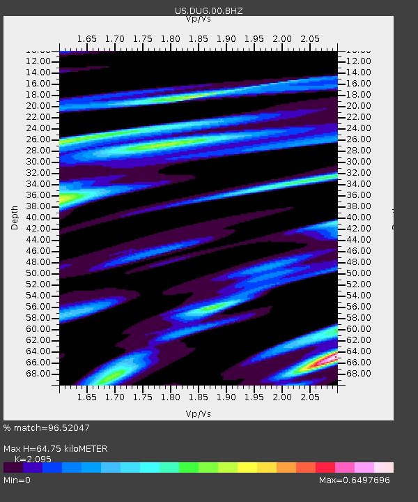
| Estimated Moho Depth: |
64.75 km |
| Estimated Crust Vp/Vs: |
2.10 |
| Assumed Crust Vp: |
6.276 km/s |
| Estimated Crust Vs: |
2.996 km/s |
| Estimated Crust Poisson's Ratio: |
0.35 |
|
| Radial Match: |
96.52047 % |
| Radial Bump: |
400 |
| Transverse Match: |
87.57927 % |
| Transverse Bump: |
400 |
| SOD ConfigId: |
558545 |
| Insert Time: |
2013-09-18 20:26:01.146 +0000 |
| GWidth: |
2.5 |
| Max Bumps: |
400 |
| Tol: |
0.001 |
|

Signal To Noise
| Channel | StoN | STA | LTA |
| US:DUG:00:BHZ:20110622T22:01:59.375024Z | 12.427585 | 7.472463E-7 | 6.012804E-8 |
| US:DUG:00:BH1:20110622T22:01:59.375024Z | 3.885005 | 2.6749194E-7 | 6.885241E-8 |
| US:DUG:00:BH2:20110622T22:01:59.375024Z | 3.209728 | 2.2220655E-7 | 6.9229095E-8 |
| Arrivals |
| Ps | 12 SECOND |
| PpPs | 31 SECOND |
| PsPs/PpSs | 43 SECOND |


