You are here: Home > Network List > US - United States National Seismic Network Stations List
> Station EGAK Eagle, Central Alaska, Alaska, USA > Earthquake Result Viewer
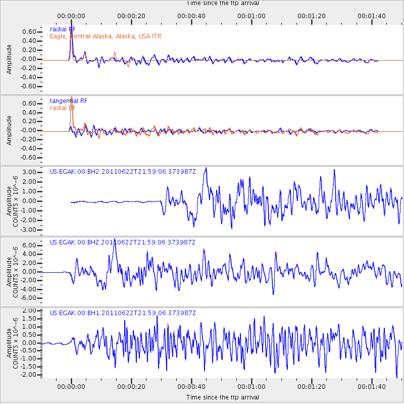
EGAK Eagle, Central Alaska, Alaska, USA - Earthquake Result Viewer

| Earthquake location: |
Near East Coast Of Honshu, Japan |
| Earthquake latitude/longitude: |
40.0/142.2 |
| Earthquake time(UTC): |
2011/06/22 (173) 21:50:52 GMT |
| Earthquake Depth: |
33 km |
| Earthquake Magnitude: |
6.7 MW, 6.1 MB, 6.7 MW, 6.7 MS |
| Earthquake Catalog/Contributor: |
NEIC PDE/NEIC PDE-M |
|
| Network: |
US United States National Seismic Network |
| Station: |
EGAK Eagle, Central Alaska, Alaska, USA |
| Lat/Lon: |
64.78 N/141.16 W |
| Elevation: |
297 m |
|
| Distance: |
49.2 deg |
| Az: |
33.444 deg |
| Baz: |
278.634 deg |
| Ray Param: |
0.068820745 |
| Estimated Moho Depth: |
33.25 km |
| Estimated Crust Vp/Vs: |
1.85 |
| Assumed Crust Vp: |
6.566 km/s |
| Estimated Crust Vs: |
3.554 km/s |
| Estimated Crust Poisson's Ratio: |
0.29 |
|
| Radial Match: |
93.15212 % |
| Radial Bump: |
400 |
| Transverse Match: |
84.70991 % |
| Transverse Bump: |
400 |
| SOD ConfigId: |
558545 |
| Insert Time: |
2013-09-18 20:26:06.243 +0000 |
| GWidth: |
2.5 |
| Max Bumps: |
400 |
| Tol: |
0.001 |
|
Signal To Noise
| Channel | StoN | STA | LTA |
| US:EGAK:00:BHZ:20110622T21:59:06.373987Z | 26.18204 | 1.2969639E-6 | 4.95364E-8 |
| US:EGAK:00:BH1:20110622T21:59:06.373987Z | 4.9212723 | 2.6073056E-7 | 5.2980315E-8 |
| US:EGAK:00:BH2:20110622T21:59:06.373987Z | 14.177233 | 6.8336124E-7 | 4.8201315E-8 |
| Arrivals |
| Ps | 4.6 SECOND |
| PpPs | 14 SECOND |
| PsPs/PpSs | 18 SECOND |


