MNTX Cornudas Mountains, Texas, USA - Earthquake Result Viewer
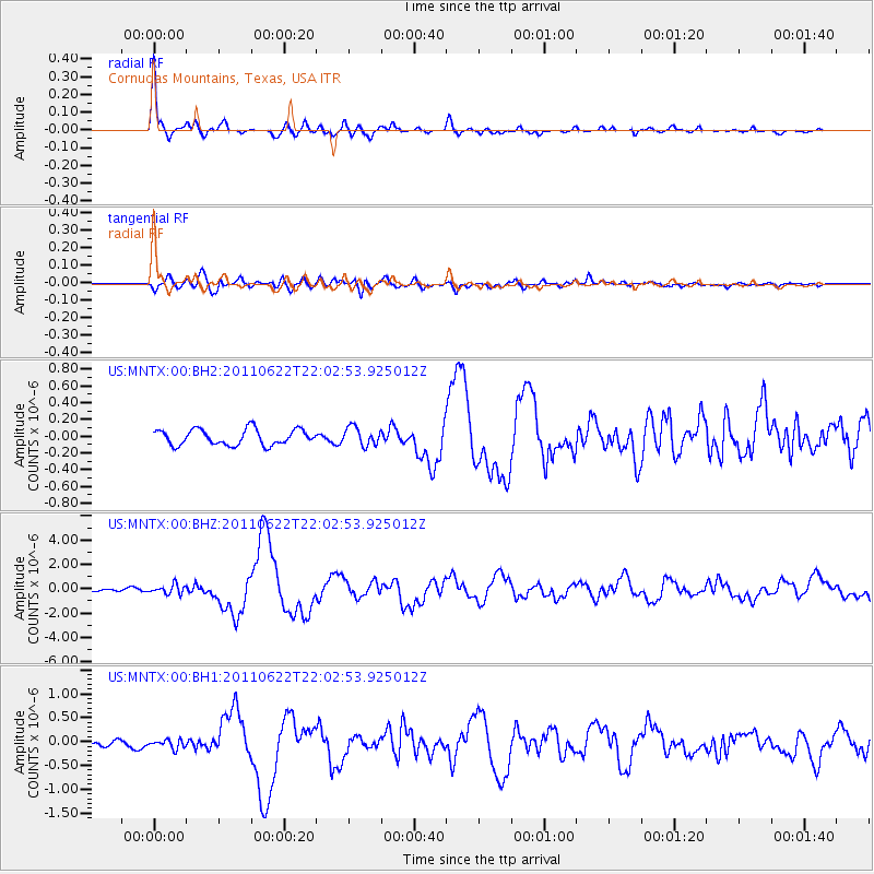
Earthquake location: Near East Coast Of Honshu, Japan
Earthquake latitude/longitude: 40.0/142.2
Earthquake time(UTC): 2011/06/22 (173) 21:50:52 GMT
Earthquake Depth: 33 km
Earthquake Magnitude: 6.7 MW, 6.1 MB, 6.7 MW, 6.7 MS
Earthquake Catalog/Contributor: NEIC PDE/NEIC PDE-M
Network: US United States National Seismic Network
Station: MNTX Cornudas Mountains, Texas, USA
Lat/Lon: 31.70 N/105.38 W
Elevation: 404 m
Distance: 85.1 deg
Az: 52.265 deg
Baz: 314.507 deg
Ray Param: 0.044932205
Estimated Moho Depth: 46.75 km
Estimated Crust Vp/Vs: 1.84
Assumed Crust Vp: 6.361 km/s
Estimated Crust Vs: 3.462 km/s
Estimated Crust Poisson's Ratio: 0.29
Radial Match: 95.164 %
Radial Bump: 296
Transverse Match: 79.80998 %
Transverse Bump: 400
SOD ConfigId: 558545
Insert Time: 2013-09-18 20:26:47.533 +0000
GWidth: 2.5
Max Bumps: 400
Tol: 0.001

Signal To Noise

ChannelStoNSTALTA
US:MNTX:00:BHZ:20110622T22:02:53.925012Z2.89899333.738431E-71.2895619E-7
US:MNTX:00:BH1:20110622T22:02:53.925012Z0.90204771.0751484E-71.1918976E-7
US:MNTX:00:BH2:20110622T22:02:53.925012Z1.15864031.0823054E-79.3411685E-8
Arrivals
Ps6.3 SECOND
PpPs20 SECOND
PsPs/PpSs27 SECOND