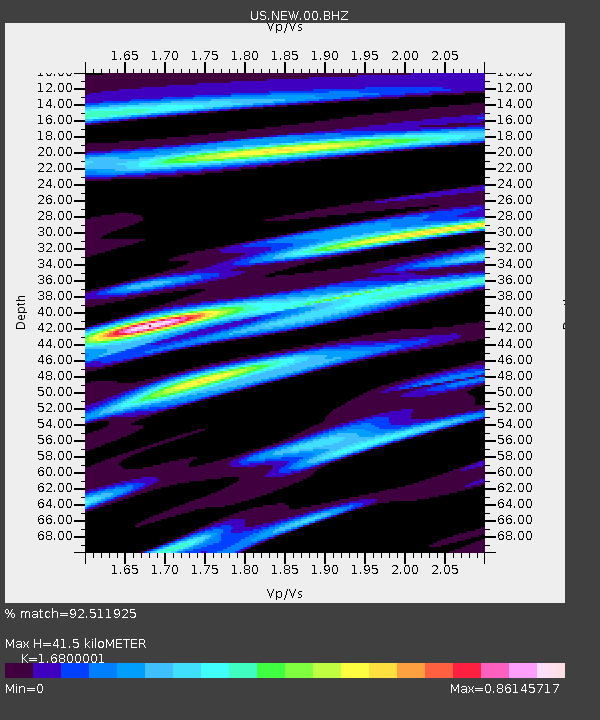
NEW Newport, Washington, USA - Earthquake Result Viewer
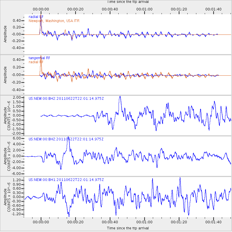
Earthquake location: Near East Coast Of Honshu, Japan
Earthquake latitude/longitude: 40.0/142.2
Earthquake time(UTC): 2011/06/22 (173) 21:50:52 GMT
Earthquake Depth: 33 km
Earthquake Magnitude: 6.7 MW, 6.1 MB, 6.7 MW, 6.7 MS
Earthquake Catalog/Contributor: NEIC PDE/NEIC PDE-M
Network: US United States National Seismic Network
Station: NEW Newport, Washington, USA
Lat/Lon: 48.26 N/117.12 W
Elevation: 760 m
Distance: 67.6 deg
Az: 45.245 deg
Baz: 305.225 deg
Ray Param: 0.05678673
Estimated Moho Depth: 41.5 km
Estimated Crust Vp/Vs: 1.68
Assumed Crust Vp: 6.571 km/s
Estimated Crust Vs: 3.911 km/s
Estimated Crust Poisson's Ratio: 0.23
Radial Match: 92.511925 %
Radial Bump: 400
Transverse Match: 80.820175 %
Transverse Bump: 400
SOD ConfigId: 558545
Insert Time: 2013-09-18 20:26:56.993 +0000
GWidth: 2.5
Max Bumps: 400
Tol: 0.001

Signal To Noise

ChannelStoNSTALTA
US:NEW:00:BHZ:20110622T22:01:14.975Z15.5807339.531404E-76.11743E-8
US:NEW:00:BH1:20110622T22:01:14.975Z2.2658781.67688E-77.4005754E-8
US:NEW:00:BH2:20110622T22:01:14.975Z4.8937532.7866182E-75.6942355E-8
Arrivals
Ps4.5 SECOND
PpPs16 SECOND
PsPs/PpSs21 SECOND