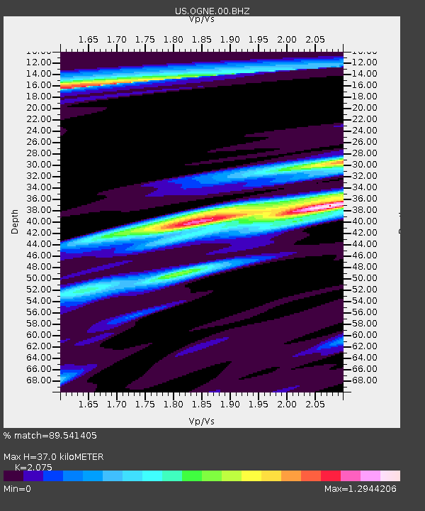
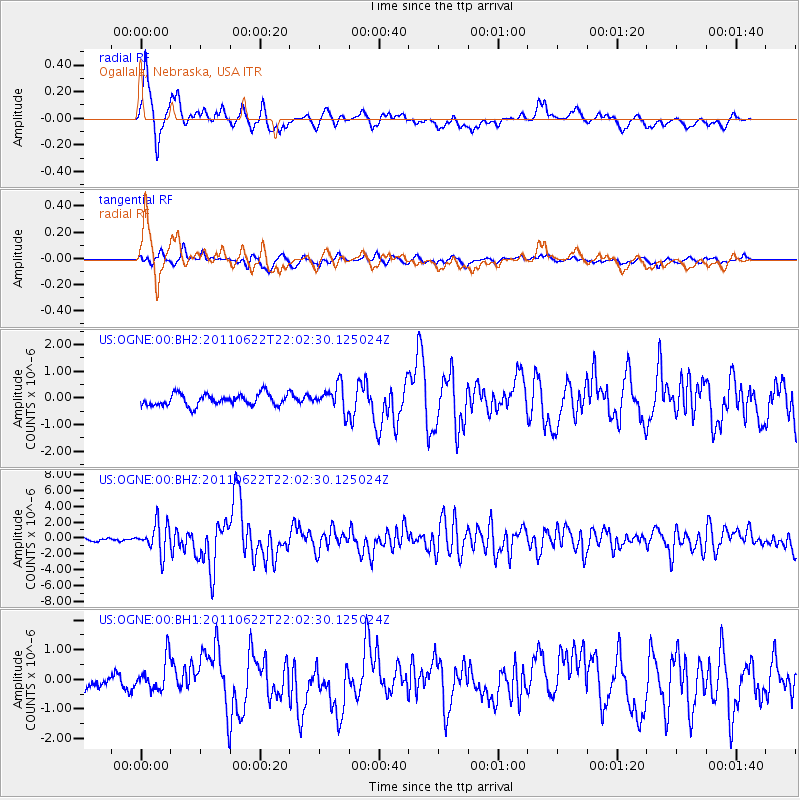
OGNE Ogallala, Nebraska, USA - Earthquake Result Viewer

Earthquake location: Near East Coast Of Honshu, Japan
Earthquake latitude/longitude: 40.0/142.2
Earthquake time(UTC): 2011/06/22 (173) 21:50:52 GMT
Earthquake Depth: 33 km
Earthquake Magnitude: 6.7 MW, 6.1 MB, 6.7 MW, 6.7 MS
Earthquake Catalog/Contributor: NEIC PDE/NEIC PDE-M
Network: US United States National Seismic Network
Station: OGNE Ogallala, Nebraska, USA
Lat/Lon: 40.95 N/102.03 W
Elevation: 0.0 m
Distance: 80.5 deg
Az: 43.76 deg
Baz: 315.426 deg
Ray Param: 0.04816811
Estimated Moho Depth: 37.0 km
Estimated Crust Vp/Vs: 2.08
Assumed Crust Vp: 6.483 km/s
Estimated Crust Vs: 3.124 km/s
Estimated Crust Poisson's Ratio: 0.35
Radial Match: 89.541405 %
Radial Bump: 374
Transverse Match: 59.2213 %
Transverse Bump: 400
SOD ConfigId: 558545
Insert Time: 2013-09-18 20:27:05.974 +0000
GWidth: 2.5
Max Bumps: 400
Tol: 0.001

Signal To Noise

ChannelStoNSTALTA
US:OGNE:00:BHZ:20110622T22:02:30.125024Z14.53171.8747847E-61.2901344E-7
US:OGNE:00:BH1:20110622T22:02:30.125024Z1.59356385.2235333E-73.277894E-7
US:OGNE:00:BH2:20110622T22:02:30.125024Z2.1864584.775647E-72.184193E-7
Arrivals
Ps6.3 SECOND
PpPs17 SECOND
PsPs/PpSs23 SECOND