You are here: Home > Network List > US - United States National Seismic Network Stations List
> Station WRAK Wrangell Island, Southeastern Alaska, Alaska, USA > Earthquake Result Viewer
WRAK Wrangell Island, Southeastern Alaska, Alaska, USA - Earthquake Result Viewer
| Earthquake location: |
Near East Coast Of Honshu, Japan |
| Earthquake latitude/longitude: |
40.0/142.2 |
| Earthquake time(UTC): |
2011/06/22 (173) 21:50:52 GMT |
| Earthquake Depth: |
33 km |
| Earthquake Magnitude: |
6.7 MW, 6.1 MB, 6.7 MW, 6.7 MS |
| Earthquake Catalog/Contributor: |
NEIC PDE/NEIC PDE-M |
|
| Network: |
US United States National Seismic Network |
| Station: |
WRAK Wrangell Island, Southeastern Alaska, Alaska, USA |
| Lat/Lon: |
56.42 N/132.35 W |
| Elevation: |
81 m |
|
| Distance: |
55.5 deg |
| Az: |
42.203 deg |
| Baz: |
291.688 deg |
| Ray Param: |
0.064661145 |
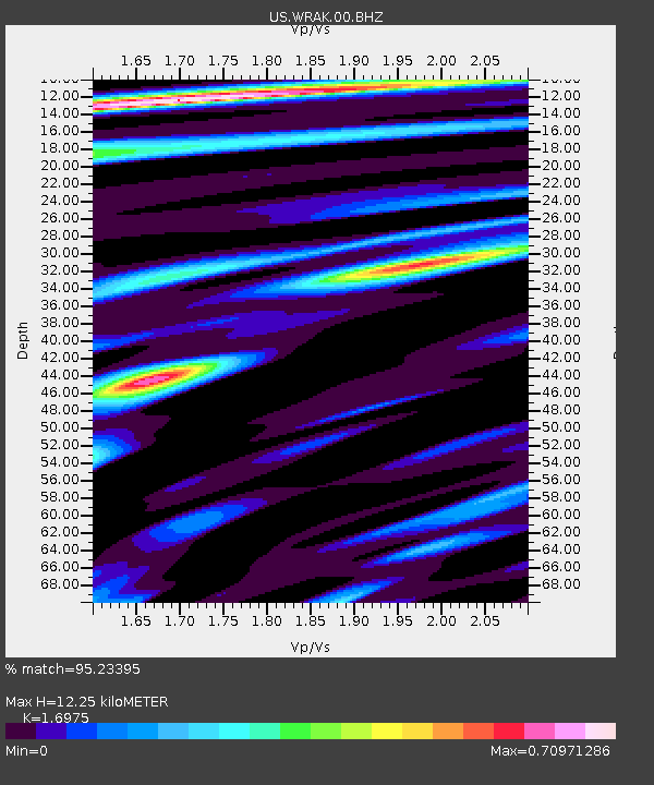
| Estimated Moho Depth: |
12.25 km |
| Estimated Crust Vp/Vs: |
1.70 |
| Assumed Crust Vp: |
6.597 km/s |
| Estimated Crust Vs: |
3.887 km/s |
| Estimated Crust Poisson's Ratio: |
0.23 |
|
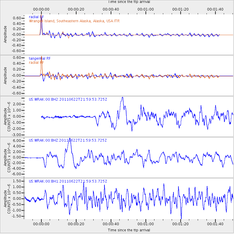
| Radial Match: |
95.23395 % |
| Radial Bump: |
400 |
| Transverse Match: |
83.28171 % |
| Transverse Bump: |
400 |
| SOD ConfigId: |
558545 |
| Insert Time: |
2013-09-18 20:27:28.615 +0000 |
| GWidth: |
2.5 |
| Max Bumps: |
400 |
| Tol: |
0.001 |
|
Signal To Noise
| Channel | StoN | STA | LTA |
| US:WRAK:00:BHZ:20110622T21:59:53.725Z | 12.214385 | 1.4372933E-6 | 1.1767219E-7 |
| US:WRAK:00:BH1:20110622T21:59:53.725Z | 3.221613 | 3.8049504E-7 | 1.18106996E-7 |
| US:WRAK:00:BH2:20110622T21:59:53.725Z | 6.3114643 | 5.704345E-7 | 9.0380695E-8 |
| Arrivals |
| Ps | 1.4 SECOND |
| PpPs | 4.7 SECOND |
| PsPs/PpSs | 6.1 SECOND |


