WUAZ Wupatki, Arizona, USA - Earthquake Result Viewer
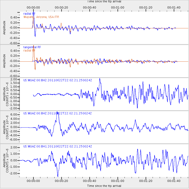
Earthquake location: Near East Coast Of Honshu, Japan
Earthquake latitude/longitude: 40.0/142.2
Earthquake time(UTC): 2011/06/22 (173) 21:50:52 GMT
Earthquake Depth: 33 km
Earthquake Magnitude: 6.7 MW, 6.1 MB, 6.7 MW, 6.7 MS
Earthquake Catalog/Contributor: NEIC PDE/NEIC PDE-M
Network: US United States National Seismic Network
Station: WUAZ Wupatki, Arizona, USA
Lat/Lon: 35.52 N/111.37 W
Elevation: 1592 m
Distance: 78.9 deg
Az: 52.887 deg
Baz: 311.289 deg
Ray Param: 0.049289357
Estimated Moho Depth: 50.25 km
Estimated Crust Vp/Vs: 1.65
Assumed Crust Vp: 6.207 km/s
Estimated Crust Vs: 3.75 km/s
Estimated Crust Poisson's Ratio: 0.21
Radial Match: 94.83138 %
Radial Bump: 400
Transverse Match: 81.875854 %
Transverse Bump: 400
SOD ConfigId: 558545
Insert Time: 2013-09-18 20:27:32.094 +0000
GWidth: 2.5
Max Bumps: 400
Tol: 0.001

Signal To Noise

ChannelStoNSTALTA
US:WUAZ:00:BHZ:20110622T22:02:21.250024Z7.2478546.085247E-78.395929E-8
US:WUAZ:00:BH1:20110622T22:02:21.250024Z4.73123462.9973214E-76.3351784E-8
US:WUAZ:00:BH2:20110622T22:02:21.250024Z3.0973262.7396433E-78.8451884E-8
Arrivals
Ps5.5 SECOND
PpPs21 SECOND
PsPs/PpSs26 SECOND