You are here: Home > Network List > CU - Caribbean Network (USGS) Stations List
> Station GTBY Guantanamo Bay, Cuba > Earthquake Result Viewer
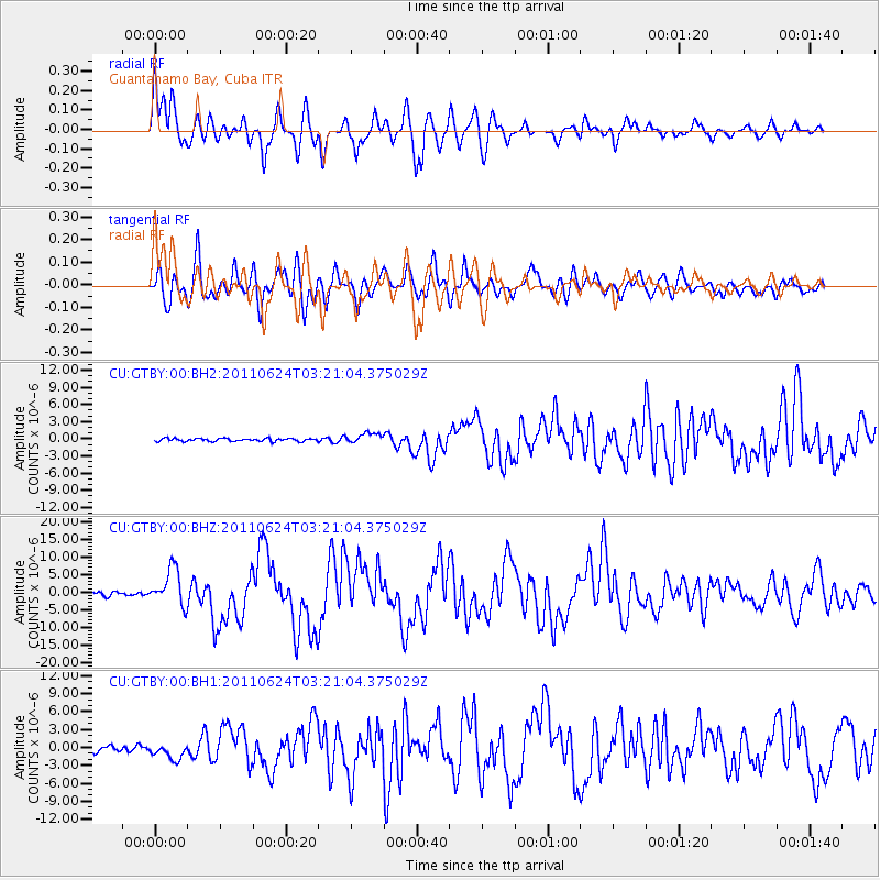
GTBY Guantanamo Bay, Cuba - Earthquake Result Viewer

| Earthquake location: |
Fox Islands, Aleutian Islands |
| Earthquake latitude/longitude: |
52.0/-171.8 |
| Earthquake time(UTC): |
2011/06/24 (175) 03:09:39 GMT |
| Earthquake Depth: |
52 km |
| Earthquake Magnitude: |
6.9 MB, 7.3 MW, 7.3 MW |
| Earthquake Catalog/Contributor: |
WHDF/NEIC |
|
| Network: |
CU Caribbean Network (USGS) |
| Station: |
GTBY Guantanamo Bay, Cuba |
| Lat/Lon: |
19.93 N/75.11 W |
| Elevation: |
79 m |
|
| Distance: |
78.6 deg |
| Az: |
72.429 deg |
| Baz: |
321.264 deg |
| Ray Param: |
0.049466975 |
| Estimated Moho Depth: |
39.25 km |
| Estimated Crust Vp/Vs: |
2.00 |
| Assumed Crust Vp: |
6.048 km/s |
| Estimated Crust Vs: |
3.024 km/s |
| Estimated Crust Poisson's Ratio: |
0.33 |
|
| Radial Match: |
90.94523 % |
| Radial Bump: |
400 |
| Transverse Match: |
75.27719 % |
| Transverse Bump: |
400 |
| SOD ConfigId: |
558545 |
| Insert Time: |
2013-09-18 20:28:04.450 +0000 |
| GWidth: |
2.5 |
| Max Bumps: |
400 |
| Tol: |
0.001 |
|
Signal To Noise
| Channel | StoN | STA | LTA |
| CU:GTBY:00:BHZ:20110624T03:21:04.375029Z | 13.3242855 | 5.242438E-6 | 3.9344982E-7 |
| CU:GTBY:00:BH1:20110624T03:21:04.375029Z | 2.9947283 | 1.288219E-6 | 4.3016223E-7 |
| CU:GTBY:00:BH2:20110624T03:21:04.375029Z | 3.488565 | 8.9347367E-7 | 2.5611496E-7 |
| Arrivals |
| Ps | 6.6 SECOND |
| PpPs | 19 SECOND |
| PsPs/PpSs | 26 SECOND |


