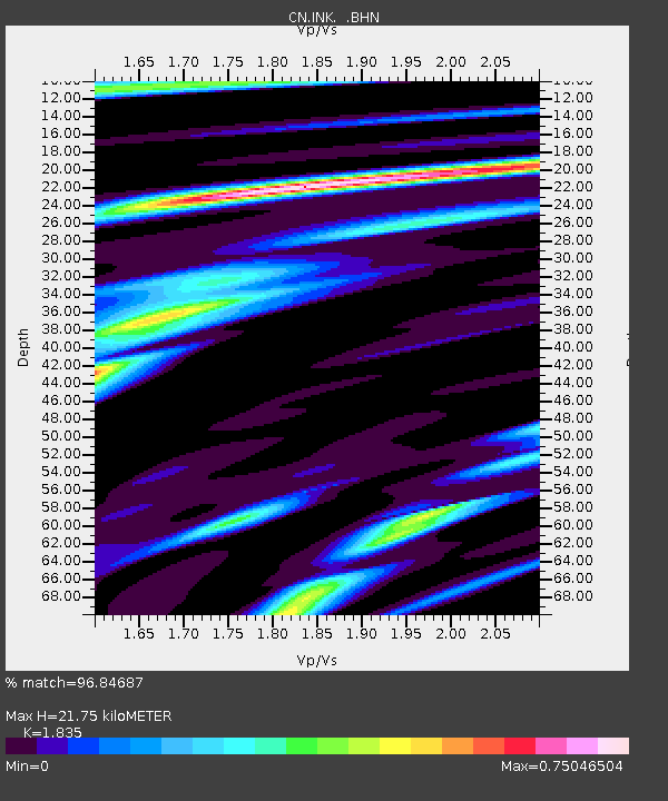
INK INUVIK, N.W.T. - Earthquake Result Viewer

Earthquake location: Near Coast Of Jalisco, Mexico
Earthquake latitude/longitude: 18.8/-104.4
Earthquake time(UTC): 2001/05/20 (140) 04:21:43 GMT
Earthquake Depth: 33 km
Earthquake Magnitude: 5.5 MB, 6.0 MS, 6.5 MD, 6.3 MW
Earthquake Catalog/Contributor: WHDF/NEIC
Network: CN Canadian National Seismograph Network
Station: INK INUVIK, N.W.T.
Lat/Lon: 68.31 N/133.52 W
Elevation: 40 m
Distance: 52.7 deg
Az: 346.88 deg
Baz: 144.668 deg
Ray Param: 0.06650318
Estimated Moho Depth: 21.75 km
Estimated Crust Vp/Vs: 1.84
Assumed Crust Vp: 6.171 km/s
Estimated Crust Vs: 3.363 km/s
Estimated Crust Poisson's Ratio: 0.29
Radial Match: 96.84687 %
Radial Bump: 349
Transverse Match: 79.546555 %
Transverse Bump: 400
SOD ConfigId: 4714
Insert Time: 2010-02-27 06:06:12.011 +0000
GWidth: 2.5
Max Bumps: 400
Tol: 0.001

Signal To Noise

ChannelStoNSTALTA
CN:INK: :BHN:20010520T04:30:24.799004Z2.6417391069.5594404.86948
CN:INK: :BHE:20010520T04:30:24.799004Z2.3137774570.19025246.43263
CN:INK: :BHZ:20010520T04:30:24.799004Z4.8509372529.6223521.4709
Arrivals
Ps3.1 SECOND
PpPs9.5 SECOND
PsPs/PpSs13 SECOND