You are here: Home > Network List > US - United States National Seismic Network Stations List
> Station AMTX Amarillo, Texas, USA > Earthquake Result Viewer
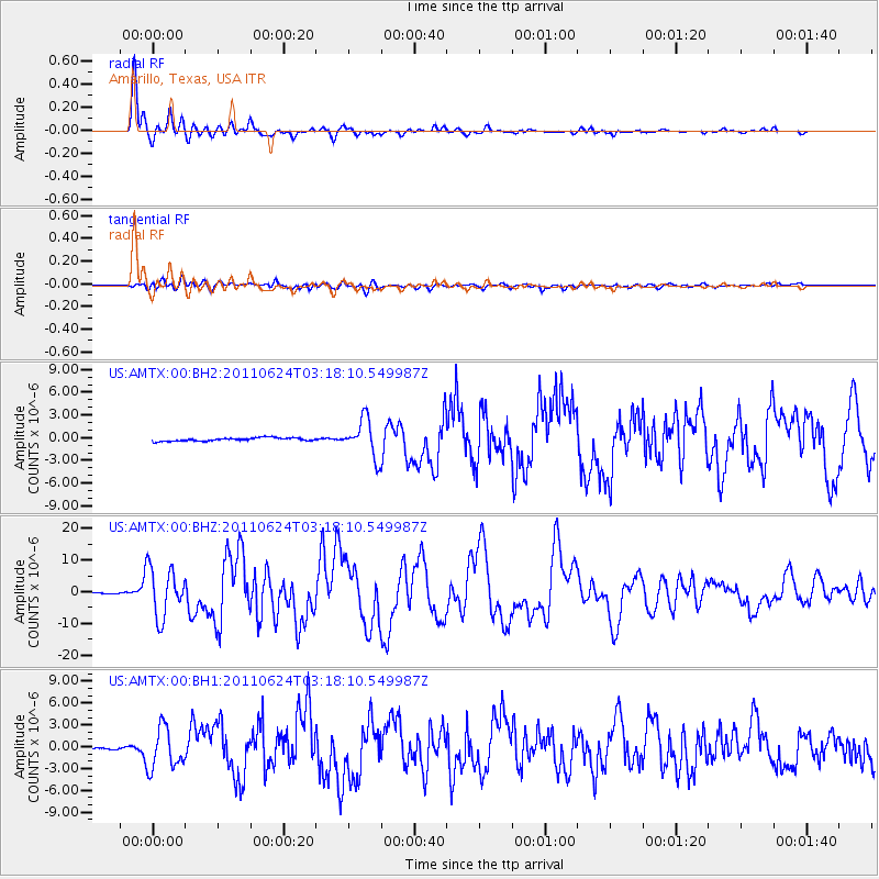
AMTX Amarillo, Texas, USA - Earthquake Result Viewer
*The percent match for this event was below the threshold and hence no stack was calculated.
| Earthquake location: |
Fox Islands, Aleutian Islands |
| Earthquake latitude/longitude: |
52.0/-171.8 |
| Earthquake time(UTC): |
2011/06/24 (175) 03:09:39 GMT |
| Earthquake Depth: |
52 km |
| Earthquake Magnitude: |
6.9 MB, 7.3 MW, 7.3 MW |
| Earthquake Catalog/Contributor: |
WHDF/NEIC |
|
| Network: |
US United States National Seismic Network |
| Station: |
AMTX Amarillo, Texas, USA |
| Lat/Lon: |
34.53 N/101.41 W |
| Elevation: |
1010 m |
|
| Distance: |
52.1 deg |
| Az: |
80.447 deg |
| Baz: |
312.471 deg |
| Ray Param: |
$rayparam |
*The percent match for this event was below the threshold and hence was not used in the summary stack. |
|
| Radial Match: |
97.238884 % |
| Radial Bump: |
400 |
| Transverse Match: |
84.801865 % |
| Transverse Bump: |
400 |
| SOD ConfigId: |
558545 |
| Insert Time: |
2013-09-18 20:30:41.090 +0000 |
| GWidth: |
2.5 |
| Max Bumps: |
400 |
| Tol: |
0.001 |
|
Signal To Noise
| Channel | StoN | STA | LTA |
| US:AMTX:00:BHZ:20110624T03:18:10.549987Z | 84.758865 | 7.747979E-6 | 9.1412026E-8 |
| US:AMTX:00:BH1:20110624T03:18:10.549987Z | 29.342625 | 2.8336678E-6 | 9.6571725E-8 |
| US:AMTX:00:BH2:20110624T03:18:10.549987Z | 15.698817 | 2.8460836E-6 | 1.8129286E-7 |
| Arrivals |
| Ps | |
| PpPs | |
| PsPs/PpSs | |


