You are here: Home > Network List > US - United States National Seismic Network Stations List
> Station EGMT Eagleton, Montana, USA > Earthquake Result Viewer
EGMT Eagleton, Montana, USA - Earthquake Result Viewer
*The percent match for this event was below the threshold and hence no stack was calculated.
| Earthquake location: |
Fox Islands, Aleutian Islands |
| Earthquake latitude/longitude: |
52.0/-171.8 |
| Earthquake time(UTC): |
2011/06/24 (175) 03:09:39 GMT |
| Earthquake Depth: |
52 km |
| Earthquake Magnitude: |
6.9 MB, 7.3 MW, 7.3 MW |
| Earthquake Catalog/Contributor: |
WHDF/NEIC |
|
| Network: |
US United States National Seismic Network |
| Station: |
EGMT Eagleton, Montana, USA |
| Lat/Lon: |
48.02 N/109.75 W |
| Elevation: |
1055 m |
|
| Distance: |
39.0 deg |
| Az: |
70.462 deg |
| Baz: |
299.894 deg |
| Ray Param: |
$rayparam |
*The percent match for this event was below the threshold and hence was not used in the summary stack. |
|
| Radial Match: |
62.947826 % |
| Radial Bump: |
322 |
| Transverse Match: |
81.57307 % |
| Transverse Bump: |
196 |
| SOD ConfigId: |
558545 |
| Insert Time: |
2013-09-18 20:31:14.328 +0000 |
| GWidth: |
2.5 |
| Max Bumps: |
400 |
| Tol: |
0.001 |
|
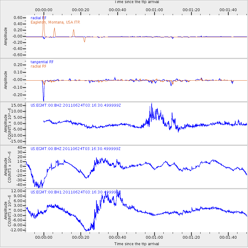
Signal To Noise
| Channel | StoN | STA | LTA |
| US:EGMT:00:BHZ:20110624T03:16:30.499999Z | 1.6366392 | 3.3808188E-5 | 2.065708E-5 |
| US:EGMT:00:BH1:20110624T03:16:30.499999Z | 0.47032338 | 1.9255522E-6 | 4.094102E-6 |
| US:EGMT:00:BH2:20110624T03:16:30.499999Z | 2.1039145 | 3.172923E-6 | 1.5081046E-6 |
| Arrivals |
| Ps | |
| PpPs | |
| PsPs/PpSs | |


