You are here: Home > Network List > US - United States National Seismic Network Stations List
> Station ERPA Erie, Pennsylvania, USA > Earthquake Result Viewer
ERPA Erie, Pennsylvania, USA - Earthquake Result Viewer
| Earthquake location: |
Fox Islands, Aleutian Islands |
| Earthquake latitude/longitude: |
52.0/-171.8 |
| Earthquake time(UTC): |
2011/06/24 (175) 03:09:39 GMT |
| Earthquake Depth: |
52 km |
| Earthquake Magnitude: |
6.9 MB, 7.3 MW, 7.3 MW |
| Earthquake Catalog/Contributor: |
WHDF/NEIC |
|
| Network: |
US United States National Seismic Network |
| Station: |
ERPA Erie, Pennsylvania, USA |
| Lat/Lon: |
42.12 N/79.99 W |
| Elevation: |
306 m |
|
| Distance: |
59.3 deg |
| Az: |
59.876 deg |
| Baz: |
314.117 deg |
| Ray Param: |
0.06216597 |
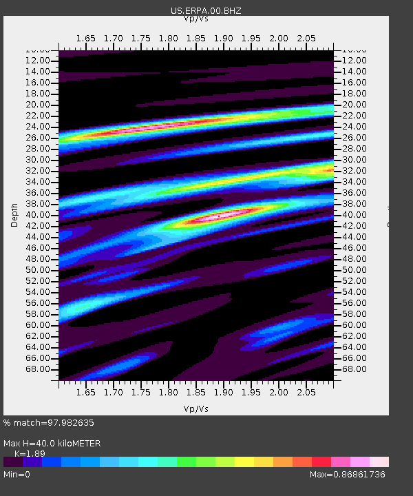
| Estimated Moho Depth: |
40.0 km |
| Estimated Crust Vp/Vs: |
1.89 |
| Assumed Crust Vp: |
6.419 km/s |
| Estimated Crust Vs: |
3.396 km/s |
| Estimated Crust Poisson's Ratio: |
0.31 |
|
| Radial Match: |
97.982635 % |
| Radial Bump: |
330 |
| Transverse Match: |
87.64355 % |
| Transverse Bump: |
400 |
| SOD ConfigId: |
558545 |
| Insert Time: |
2013-09-18 20:31:16.753 +0000 |
| GWidth: |
2.5 |
| Max Bumps: |
400 |
| Tol: |
0.001 |
|
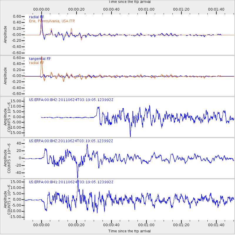
Signal To Noise
| Channel | StoN | STA | LTA |
| US:ERPA:00:BHZ:20110624T03:19:05.123992Z | 63.241043 | 1.3344573E-5 | 2.1101128E-7 |
| US:ERPA:00:BH1:20110624T03:19:05.123992Z | 22.41416 | 4.621065E-6 | 2.0616723E-7 |
| US:ERPA:00:BH2:20110624T03:19:05.123992Z | 30.475979 | 5.2116848E-6 | 1.7100959E-7 |
| Arrivals |
| Ps | 5.8 SECOND |
| PpPs | 17 SECOND |
| PsPs/PpSs | 23 SECOND |


