You are here: Home > Network List > US - United States National Seismic Network Stations List
> Station MVCO Mesa Verde, Colorado, USA > Earthquake Result Viewer
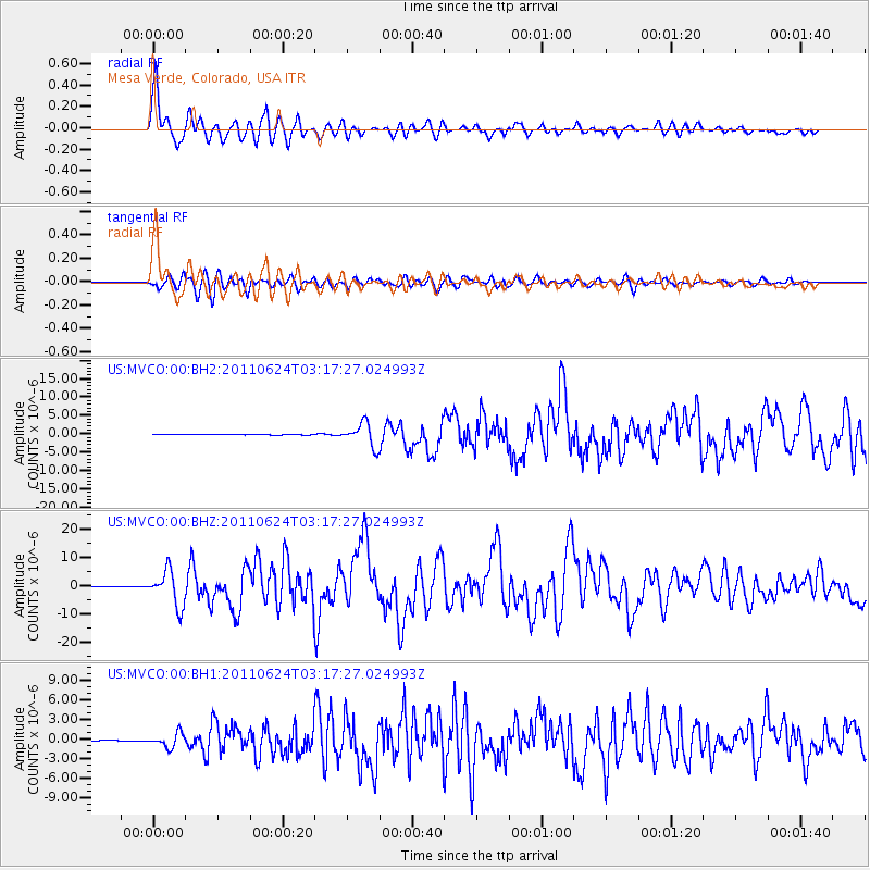
MVCO Mesa Verde, Colorado, USA - Earthquake Result Viewer

| Earthquake location: |
Fox Islands, Aleutian Islands |
| Earthquake latitude/longitude: |
52.0/-171.8 |
| Earthquake time(UTC): |
2011/06/24 (175) 03:09:39 GMT |
| Earthquake Depth: |
52 km |
| Earthquake Magnitude: |
6.9 MB, 7.3 MW, 7.3 MW |
| Earthquake Catalog/Contributor: |
WHDF/NEIC |
|
| Network: |
US United States National Seismic Network |
| Station: |
MVCO Mesa Verde, Colorado, USA |
| Lat/Lon: |
37.21 N/108.50 W |
| Elevation: |
2170 m |
|
| Distance: |
46.0 deg |
| Az: |
82.804 deg |
| Baz: |
309.878 deg |
| Ray Param: |
0.070790164 |
| Estimated Moho Depth: |
43.0 km |
| Estimated Crust Vp/Vs: |
1.81 |
| Assumed Crust Vp: |
6.476 km/s |
| Estimated Crust Vs: |
3.573 km/s |
| Estimated Crust Poisson's Ratio: |
0.28 |
|
| Radial Match: |
93.3724 % |
| Radial Bump: |
400 |
| Transverse Match: |
85.130775 % |
| Transverse Bump: |
400 |
| SOD ConfigId: |
558545 |
| Insert Time: |
2013-09-18 20:32:11.831 +0000 |
| GWidth: |
2.5 |
| Max Bumps: |
400 |
| Tol: |
0.001 |
|
Signal To Noise
| Channel | StoN | STA | LTA |
| US:MVCO:00:BHZ:20110624T03:17:27.024993Z | 86.71741 | 6.240402E-6 | 7.196251E-8 |
| US:MVCO:00:BH1:20110624T03:17:27.024993Z | 13.462547 | 1.0849177E-6 | 8.0587846E-8 |
| US:MVCO:00:BH2:20110624T03:17:27.024993Z | 46.012024 | 3.1870316E-6 | 6.926519E-8 |
| Arrivals |
| Ps | 5.7 SECOND |
| PpPs | 18 SECOND |
| PsPs/PpSs | 23 SECOND |


