You are here: Home > Network List > US - United States National Seismic Network Stations List
> Station EGMT Eagleton, Montana, USA > Earthquake Result Viewer
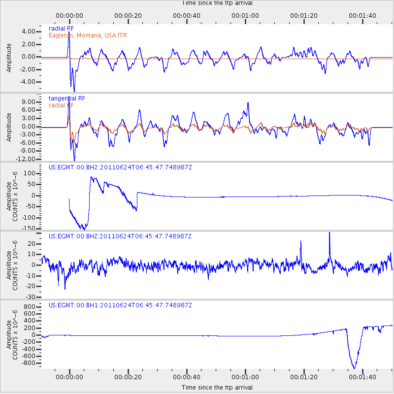
EGMT Eagleton, Montana, USA - Earthquake Result Viewer
*The percent match for this event was below the threshold and hence no stack was calculated.
| Earthquake location: |
Santa Cruz Islands |
| Earthquake latitude/longitude: |
-10.9/165.9 |
| Earthquake time(UTC): |
2011/06/24 (175) 06:33:07 GMT |
| Earthquake Depth: |
72 km |
| Earthquake Magnitude: |
5.6 MB |
| Earthquake Catalog/Contributor: |
WHDF/NEIC |
|
| Network: |
US United States National Seismic Network |
| Station: |
EGMT Eagleton, Montana, USA |
| Lat/Lon: |
48.02 N/109.75 W |
| Elevation: |
1055 m |
|
| Distance: |
94.3 deg |
| Az: |
42.055 deg |
| Baz: |
258.517 deg |
| Ray Param: |
$rayparam |
*The percent match for this event was below the threshold and hence was not used in the summary stack. |
|
| Radial Match: |
29.789658 % |
| Radial Bump: |
400 |
| Transverse Match: |
31.680145 % |
| Transverse Bump: |
400 |
| SOD ConfigId: |
558545 |
| Insert Time: |
2013-09-18 20:34:12.999 +0000 |
| GWidth: |
2.5 |
| Max Bumps: |
400 |
| Tol: |
0.001 |
|
Signal To Noise
| Channel | StoN | STA | LTA |
| US:EGMT:00:BHZ:20110624T06:45:47.748987Z | 1.2682135 | 6.1838873E-6 | 4.8760617E-6 |
| US:EGMT:00:BH1:20110624T06:45:47.748987Z | 0.536779 | 3.0512942E-5 | 5.6844518E-5 |
| US:EGMT:00:BH2:20110624T06:45:47.748987Z | 0.20434047 | 1.4755667E-5 | 7.221118E-5 |
| Arrivals |
| Ps | |
| PpPs | |
| PsPs/PpSs | |


