You are here: Home > Network List > TA - USArray Transportable Network (new EarthScope stations) Stations List
> Station Z41A Richland Creek Farm, El Dorado, AR, USA > Earthquake Result Viewer
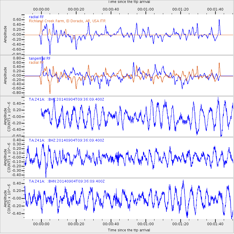
Z41A Richland Creek Farm, El Dorado, AR, USA - Earthquake Result Viewer
*The percent match for this event was below the threshold and hence no stack was calculated.
| Earthquake location: |
Near Coast Of Northern Chile |
| Earthquake latitude/longitude: |
-20.7/-70.4 |
| Earthquake time(UTC): |
2014/09/04 (247) 09:26:51 GMT |
| Earthquake Depth: |
28 km |
| Earthquake Magnitude: |
5.0 MW |
| Earthquake Catalog/Contributor: |
ISC/ISC |
|
| Network: |
TA USArray Transportable Network (new EarthScope stations) |
| Station: |
Z41A Richland Creek Farm, El Dorado, AR, USA |
| Lat/Lon: |
33.26 N/92.80 W |
| Elevation: |
62 m |
|
| Distance: |
57.7 deg |
| Az: |
337.8 deg |
| Baz: |
155.024 deg |
| Ray Param: |
$rayparam |
*The percent match for this event was below the threshold and hence was not used in the summary stack. |
|
| Radial Match: |
66.01798 % |
| Radial Bump: |
400 |
| Transverse Match: |
58.846153 % |
| Transverse Bump: |
400 |
| SOD ConfigId: |
3390531 |
| Insert Time: |
2019-04-13 20:33:52.303 +0000 |
| GWidth: |
2.5 |
| Max Bumps: |
400 |
| Tol: |
0.001 |
|
Signal To Noise
| Channel | StoN | STA | LTA |
| TA:Z41A: :BHZ:20140904T09:36:09.400Z | 2.237577 | 2.0978764E-7 | 9.375662E-8 |
| TA:Z41A: :BHN:20140904T09:36:09.400Z | 1.016868 | 1.4618179E-7 | 1.437569E-7 |
| TA:Z41A: :BHE:20140904T09:36:09.400Z | 1.2883347 | 2.669252E-7 | 2.0718622E-7 |
| Arrivals |
| Ps | |
| PpPs | |
| PsPs/PpSs | |


