You are here: Home > Network List > IU - Global Seismograph Network (GSN - IRIS/USGS) Stations List
> Station PMG Port Moresby, New Guinea > Earthquake Result Viewer
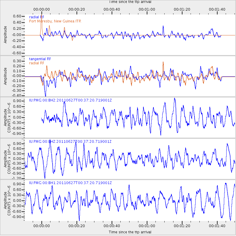
PMG Port Moresby, New Guinea - Earthquake Result Viewer
*The percent match for this event was below the threshold and hence no stack was calculated.
| Earthquake location: |
Tonga Islands |
| Earthquake latitude/longitude: |
-17.1/-173.7 |
| Earthquake time(UTC): |
2011/06/27 (178) 00:30:29 GMT |
| Earthquake Depth: |
35 km |
| Earthquake Magnitude: |
5.6 MB, 5.5 MW |
| Earthquake Catalog/Contributor: |
NEIC PDE/NEIC PDE-M |
|
| Network: |
IU Global Seismograph Network (GSN - IRIS/USGS) |
| Station: |
PMG Port Moresby, New Guinea |
| Lat/Lon: |
9.40 S/147.16 E |
| Elevation: |
90 m |
|
| Distance: |
38.8 deg |
| Az: |
276.278 deg |
| Baz: |
105.565 deg |
| Ray Param: |
$rayparam |
*The percent match for this event was below the threshold and hence was not used in the summary stack. |
|
| Radial Match: |
66.20725 % |
| Radial Bump: |
400 |
| Transverse Match: |
57.031876 % |
| Transverse Bump: |
400 |
| SOD ConfigId: |
558545 |
| Insert Time: |
2013-09-18 20:44:57.846 +0000 |
| GWidth: |
2.5 |
| Max Bumps: |
400 |
| Tol: |
0.001 |
|
Signal To Noise
| Channel | StoN | STA | LTA |
| IU:PMG:00:BHZ:20110627T00:37:20.719001Z | 1.9375663 | 6.323279E-7 | 3.2635165E-7 |
| IU:PMG:00:BH1:20110627T00:37:20.719001Z | 0.93474954 | 3.1870775E-7 | 3.409552E-7 |
| IU:PMG:00:BH2:20110627T00:37:20.719001Z | 0.87329334 | 2.4596207E-7 | 2.8164885E-7 |
| Arrivals |
| Ps | |
| PpPs | |
| PsPs/PpSs | |


