You are here: Home > Network List > US - United States National Seismic Network Stations List
> Station AMTX Amarillo, Texas, USA > Earthquake Result Viewer
AMTX Amarillo, Texas, USA - Earthquake Result Viewer
*The percent match for this event was below the threshold and hence no stack was calculated.
| Earthquake location: |
Tonga Islands |
| Earthquake latitude/longitude: |
-17.1/-173.7 |
| Earthquake time(UTC): |
2011/06/27 (178) 00:30:29 GMT |
| Earthquake Depth: |
35 km |
| Earthquake Magnitude: |
5.6 MB, 5.5 MW |
| Earthquake Catalog/Contributor: |
NEIC PDE/NEIC PDE-M |
|
| Network: |
US United States National Seismic Network |
| Station: |
AMTX Amarillo, Texas, USA |
| Lat/Lon: |
34.53 N/101.41 W |
| Elevation: |
1010 m |
|
| Distance: |
85.7 deg |
| Az: |
52.062 deg |
| Baz: |
245.997 deg |
| Ray Param: |
$rayparam |
*The percent match for this event was below the threshold and hence was not used in the summary stack. |
|
| Radial Match: |
36.673737 % |
| Radial Bump: |
400 |
| Transverse Match: |
64.74816 % |
| Transverse Bump: |
400 |
| SOD ConfigId: |
558545 |
| Insert Time: |
2013-09-18 20:45:19.858 +0000 |
| GWidth: |
2.5 |
| Max Bumps: |
400 |
| Tol: |
0.001 |
|
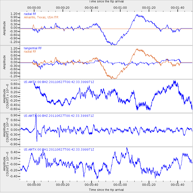
Signal To Noise
| Channel | StoN | STA | LTA |
| US:AMTX:00:BHZ:20110627T00:42:33.399971Z | 3.5667706 | 3.57114E-7 | 1.00122506E-7 |
| US:AMTX:00:BH1:20110627T00:42:33.399971Z | 1.8600448 | 2.6590766E-7 | 1.4295766E-7 |
| US:AMTX:00:BH2:20110627T00:42:33.399971Z | 0.8267183 | 2.318998E-7 | 2.8050647E-7 |
| Arrivals |
| Ps | |
| PpPs | |
| PsPs/PpSs | |


