You are here: Home > Network List > US - United States National Seismic Network Stations List
> Station DGMT Dagmar, Montana, USA > Earthquake Result Viewer
DGMT Dagmar, Montana, USA - Earthquake Result Viewer
*The percent match for this event was below the threshold and hence no stack was calculated.
| Earthquake location: |
Tonga Islands |
| Earthquake latitude/longitude: |
-17.1/-173.7 |
| Earthquake time(UTC): |
2011/06/27 (178) 00:30:29 GMT |
| Earthquake Depth: |
35 km |
| Earthquake Magnitude: |
5.6 MB, 5.5 MW |
| Earthquake Catalog/Contributor: |
NEIC PDE/NEIC PDE-M |
|
| Network: |
US United States National Seismic Network |
| Station: |
DGMT Dagmar, Montana, USA |
| Lat/Lon: |
48.47 N/104.20 W |
| Elevation: |
0.0 m |
|
| Distance: |
89.7 deg |
| Az: |
38.561 deg |
| Baz: |
243.6 deg |
| Ray Param: |
$rayparam |
*The percent match for this event was below the threshold and hence was not used in the summary stack. |
|
| Radial Match: |
53.174446 % |
| Radial Bump: |
400 |
| Transverse Match: |
52.308937 % |
| Transverse Bump: |
386 |
| SOD ConfigId: |
558545 |
| Insert Time: |
2013-09-18 20:45:30.158 +0000 |
| GWidth: |
2.5 |
| Max Bumps: |
400 |
| Tol: |
0.001 |
|
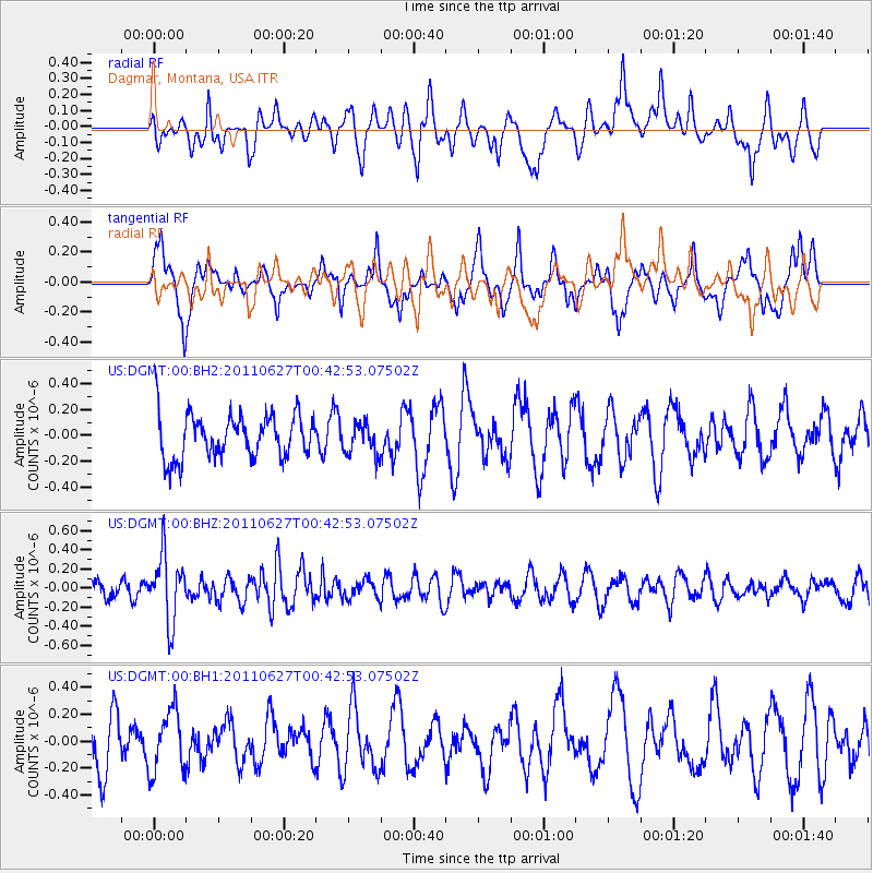
Signal To Noise
| Channel | StoN | STA | LTA |
| US:DGMT:00:BHZ:20110627T00:42:53.07502Z | 3.0952883 | 3.4501264E-7 | 1.1146381E-7 |
| US:DGMT:00:BH1:20110627T00:42:53.07502Z | 0.95411366 | 2.2547873E-7 | 2.3632272E-7 |
| US:DGMT:00:BH2:20110627T00:42:53.07502Z | 0.68238604 | 1.1919757E-7 | 1.7467762E-7 |
| Arrivals |
| Ps | |
| PpPs | |
| PsPs/PpSs | |


