You are here: Home > Network List > US - United States National Seismic Network Stations List
> Station WMOK Wichita Mountains, Oklahoma, USA > Earthquake Result Viewer
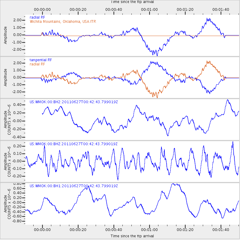
WMOK Wichita Mountains, Oklahoma, USA - Earthquake Result Viewer
*The percent match for this event was below the threshold and hence no stack was calculated.
| Earthquake location: |
Tonga Islands |
| Earthquake latitude/longitude: |
-17.1/-173.7 |
| Earthquake time(UTC): |
2011/06/27 (178) 00:30:29 GMT |
| Earthquake Depth: |
35 km |
| Earthquake Magnitude: |
5.6 MB, 5.5 MW |
| Earthquake Catalog/Contributor: |
NEIC PDE/NEIC PDE-M |
|
| Network: |
US United States National Seismic Network |
| Station: |
WMOK Wichita Mountains, Oklahoma, USA |
| Lat/Lon: |
34.74 N/98.78 W |
| Elevation: |
486 m |
|
| Distance: |
87.8 deg |
| Az: |
52.728 deg |
| Baz: |
247.521 deg |
| Ray Param: |
$rayparam |
*The percent match for this event was below the threshold and hence was not used in the summary stack. |
|
| Radial Match: |
65.326706 % |
| Radial Bump: |
400 |
| Transverse Match: |
65.0639 % |
| Transverse Bump: |
400 |
| SOD ConfigId: |
558545 |
| Insert Time: |
2013-09-18 20:46:27.173 +0000 |
| GWidth: |
2.5 |
| Max Bumps: |
400 |
| Tol: |
0.001 |
|
Signal To Noise
| Channel | StoN | STA | LTA |
| US:WMOK:00:BHZ:20110627T00:42:43.799019Z | 1.4920251 | 1.04212724E-7 | 6.984649E-8 |
| US:WMOK:00:BH1:20110627T00:42:43.799019Z | 0.6164452 | 2.4542567E-7 | 3.9813057E-7 |
| US:WMOK:00:BH2:20110627T00:42:43.799019Z | 0.59953547 | 1.1546023E-7 | 1.9258282E-7 |
| Arrivals |
| Ps | |
| PpPs | |
| PsPs/PpSs | |


