You are here: Home > Network List > US - United States National Seismic Network Stations List
> Station WUAZ Wupatki, Arizona, USA > Earthquake Result Viewer
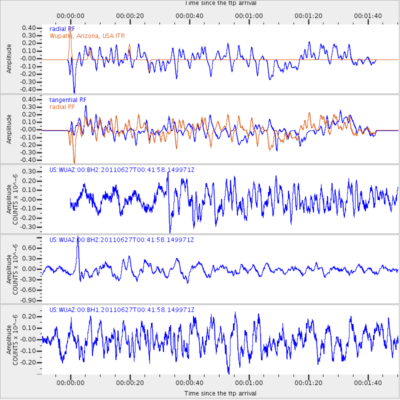
WUAZ Wupatki, Arizona, USA - Earthquake Result Viewer
*The percent match for this event was below the threshold and hence no stack was calculated.
| Earthquake location: |
Tonga Islands |
| Earthquake latitude/longitude: |
-17.1/-173.7 |
| Earthquake time(UTC): |
2011/06/27 (178) 00:30:29 GMT |
| Earthquake Depth: |
35 km |
| Earthquake Magnitude: |
5.6 MB, 5.5 MW |
| Earthquake Catalog/Contributor: |
NEIC PDE/NEIC PDE-M |
|
| Network: |
US United States National Seismic Network |
| Station: |
WUAZ Wupatki, Arizona, USA |
| Lat/Lon: |
35.52 N/111.37 W |
| Elevation: |
1592 m |
|
| Distance: |
78.9 deg |
| Az: |
47.417 deg |
| Baz: |
239.667 deg |
| Ray Param: |
$rayparam |
*The percent match for this event was below the threshold and hence was not used in the summary stack. |
|
| Radial Match: |
65.46843 % |
| Radial Bump: |
400 |
| Transverse Match: |
50.70864 % |
| Transverse Bump: |
400 |
| SOD ConfigId: |
558545 |
| Insert Time: |
2013-09-18 20:46:30.120 +0000 |
| GWidth: |
2.5 |
| Max Bumps: |
400 |
| Tol: |
0.001 |
|
Signal To Noise
| Channel | StoN | STA | LTA |
| US:WUAZ:00:BHZ:20110627T00:41:58.149971Z | 3.9033995 | 3.1189538E-7 | 7.990352E-8 |
| US:WUAZ:00:BH1:20110627T00:41:58.149971Z | 1.2795656 | 8.941371E-8 | 6.9878176E-8 |
| US:WUAZ:00:BH2:20110627T00:41:58.149971Z | 2.2313025 | 1.6454554E-7 | 7.374417E-8 |
| Arrivals |
| Ps | |
| PpPs | |
| PsPs/PpSs | |


