You are here: Home > Network List > CN - Canadian National Seismograph Network Stations List
> Station INK INUVIK, NT, CANADA.ANADA > Earthquake Result Viewer
INK INUVIK, NT, CANADA.ANADA - Earthquake Result Viewer

| Earthquake location: |
Near Coast Of Chiapas, Mexico |
| Earthquake latitude/longitude: |
15.6/-93.1 |
| Earthquake time(UTC): |
2001/11/28 (332) 14:32:32 GMT |
| Earthquake Depth: |
85 km |
| Earthquake Magnitude: |
5.7 MB, 6.4 MW, 6.4 MW |
| Earthquake Catalog/Contributor: |
WHDF/NEIC |
|
| Network: |
CN Canadian National Seismograph Network |
| Station: |
INK INUVIK, NT, CANADA.ANADA |
| Lat/Lon: |
68.31 N/133.52 W |
| Elevation: |
40 m |
|
| Distance: |
58.6 deg |
| Az: |
343.604 deg |
| Baz: |
132.969 deg |
| Ray Param: |
0.062478315 |
| Estimated Moho Depth: |
43.5 km |
| Estimated Crust Vp/Vs: |
1.60 |
| Assumed Crust Vp: |
6.171 km/s |
| Estimated Crust Vs: |
3.857 km/s |
| Estimated Crust Poisson's Ratio: |
0.18 |
|
| Radial Match: |
95.934296 % |
| Radial Bump: |
321 |
| Transverse Match: |
86.04207 % |
| Transverse Bump: |
378 |
| SOD ConfigId: |
20082 |
| Insert Time: |
2010-02-27 06:06:57.244 +0000 |
| GWidth: |
2.5 |
| Max Bumps: |
400 |
| Tol: |
0.001 |
|
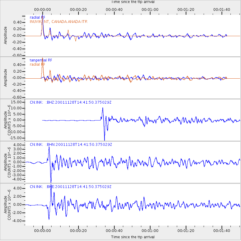
Signal To Noise
| Channel | StoN | STA | LTA |
| CN:INK: :BHN:20011128T14:41:50.375029Z | 10.397414 | 1.604932E-6 | 1.5435876E-7 |
| CN:INK: :BHE:20011128T14:41:50.375029Z | 19.561432 | 1.6784014E-6 | 8.580156E-8 |
| CN:INK: :BHZ:20011128T14:41:50.375029Z | 47.015522 | 5.072168E-6 | 1.0788284E-7 |
| Arrivals |
| Ps | 4.4 SECOND |
| PpPs | 17 SECOND |
| PsPs/PpSs | 22 SECOND |


