You are here: Home > Network List > US - United States National Seismic Network Stations List
> Station TZTN Tazewell, Tennessee, USA > Earthquake Result Viewer
TZTN Tazewell, Tennessee, USA - Earthquake Result Viewer
| Earthquake location: |
Fox Islands, Aleutian Islands |
| Earthquake latitude/longitude: |
52.0/-171.8 |
| Earthquake time(UTC): |
2011/06/27 (178) 23:27:33 GMT |
| Earthquake Depth: |
29 km |
| Earthquake Magnitude: |
5.8 MW, 5.6 MW, 5.9 MB |
| Earthquake Catalog/Contributor: |
NEIC PDE/NEIC PDE-M |
|
| Network: |
US United States National Seismic Network |
| Station: |
TZTN Tazewell, Tennessee, USA |
| Lat/Lon: |
36.54 N/83.55 W |
| Elevation: |
394 m |
|
| Distance: |
61.2 deg |
| Az: |
66.694 deg |
| Baz: |
315.17 deg |
| Ray Param: |
0.060972955 |
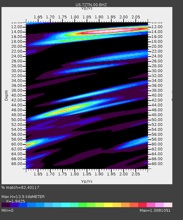
| Estimated Moho Depth: |
13.5 km |
| Estimated Crust Vp/Vs: |
1.94 |
| Assumed Crust Vp: |
6.476 km/s |
| Estimated Crust Vs: |
3.334 km/s |
| Estimated Crust Poisson's Ratio: |
0.32 |
|
| Radial Match: |
82.40117 % |
| Radial Bump: |
400 |
| Transverse Match: |
72.906 % |
| Transverse Bump: |
400 |
| SOD ConfigId: |
558545 |
| Insert Time: |
2013-09-18 20:52:11.188 +0000 |
| GWidth: |
2.5 |
| Max Bumps: |
400 |
| Tol: |
0.001 |
|

Signal To Noise
| Channel | StoN | STA | LTA |
| US:TZTN:00:BHZ:20110627T23:37:14.773987Z | 15.579825 | 7.857465E-7 | 5.0433588E-8 |
| US:TZTN:00:BH1:20110627T23:37:14.773987Z | 4.9637156 | 2.6910683E-7 | 5.4214798E-8 |
| US:TZTN:00:BH2:20110627T23:37:14.773987Z | 5.1919913 | 2.7636835E-7 | 5.3229737E-8 |
| Arrivals |
| Ps | 2.0 SECOND |
| PpPs | 5.9 SECOND |
| PsPs/PpSs | 7.9 SECOND |


