You are here: Home > Network List > US - United States National Seismic Network Stations List
> Station DGMT Dagmar, Montana, USA > Earthquake Result Viewer
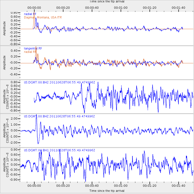
DGMT Dagmar, Montana, USA - Earthquake Result Viewer
*The percent match for this event was below the threshold and hence no stack was calculated.
| Earthquake location: |
Fox Islands, Aleutian Islands |
| Earthquake latitude/longitude: |
52.1/-171.7 |
| Earthquake time(UTC): |
2011/06/28 (179) 06:48:32 GMT |
| Earthquake Depth: |
30 km |
| Earthquake Magnitude: |
5.6 MB, 5.4 MS, 5.9 MW, 5.6 MW |
| Earthquake Catalog/Contributor: |
WHDF/NEIC |
|
| Network: |
US United States National Seismic Network |
| Station: |
DGMT Dagmar, Montana, USA |
| Lat/Lon: |
48.47 N/104.20 W |
| Elevation: |
0.0 m |
|
| Distance: |
41.9 deg |
| Az: |
67.064 deg |
| Baz: |
301.366 deg |
| Ray Param: |
$rayparam |
*The percent match for this event was below the threshold and hence was not used in the summary stack. |
|
| Radial Match: |
68.65563 % |
| Radial Bump: |
400 |
| Transverse Match: |
57.49546 % |
| Transverse Bump: |
400 |
| SOD ConfigId: |
558545 |
| Insert Time: |
2013-09-18 20:55:29.254 +0000 |
| GWidth: |
2.5 |
| Max Bumps: |
400 |
| Tol: |
0.001 |
|
Signal To Noise
| Channel | StoN | STA | LTA |
| US:DGMT:00:BHZ:20110628T06:55:49.474996Z | 14.64792 | 1.324145E-6 | 9.039816E-8 |
| US:DGMT:00:BH1:20110628T06:55:49.474996Z | 2.5703573 | 3.777455E-7 | 1.4696225E-7 |
| US:DGMT:00:BH2:20110628T06:55:49.474996Z | 3.1133046 | 3.9702962E-7 | 1.2752675E-7 |
| Arrivals |
| Ps | |
| PpPs | |
| PsPs/PpSs | |


