You are here: Home > Network List > II - Global Seismograph Network (GSN - IRIS/IDA) Stations List
> Station WRAB Tennant Creek, NT, Australia > Earthquake Result Viewer
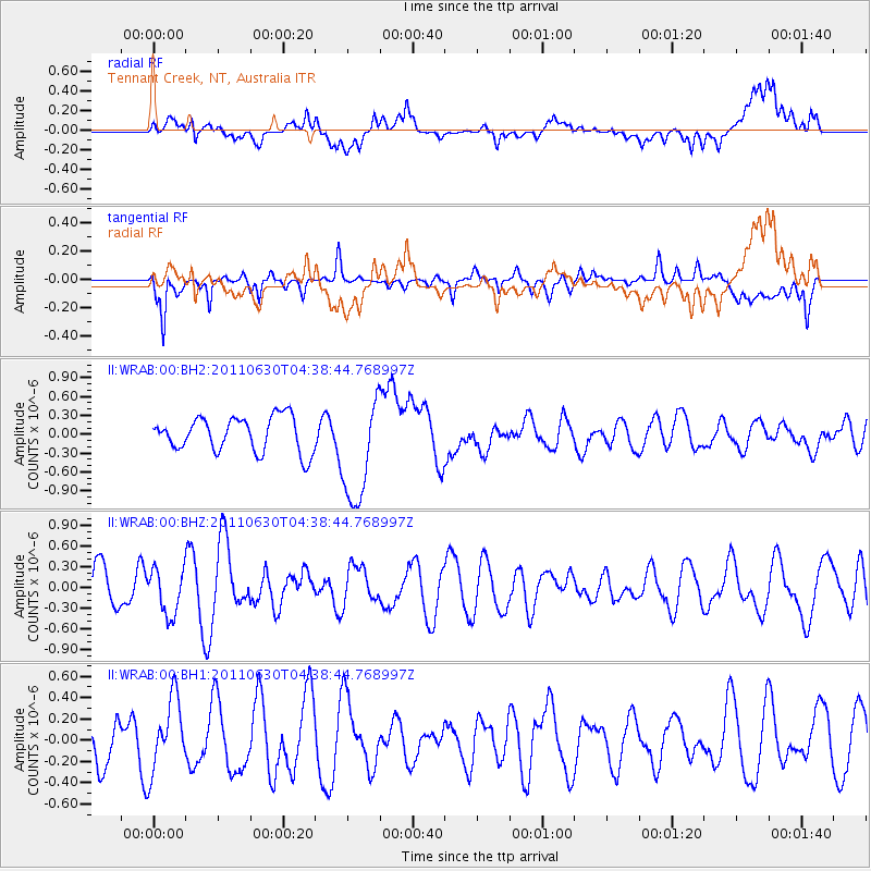
WRAB Tennant Creek, NT, Australia - Earthquake Result Viewer
*The percent match for this event was below the threshold and hence no stack was calculated.
| Earthquake location: |
Tonga Islands Region |
| Earthquake latitude/longitude: |
-23.5/-175.9 |
| Earthquake time(UTC): |
2011/06/30 (181) 04:30:54 GMT |
| Earthquake Depth: |
35 km |
| Earthquake Magnitude: |
5.6 MW, 5.6 MW |
| Earthquake Catalog/Contributor: |
NEIC PDE/NEIC PDE-M |
|
| Network: |
II Global Seismograph Network (GSN - IRIS/IDA) |
| Station: |
WRAB Tennant Creek, NT, Australia |
| Lat/Lon: |
19.93 S/134.36 E |
| Elevation: |
366 m |
|
| Distance: |
46.2 deg |
| Az: |
264.415 deg |
| Baz: |
103.766 deg |
| Ray Param: |
$rayparam |
*The percent match for this event was below the threshold and hence was not used in the summary stack. |
|
| Radial Match: |
53.130177 % |
| Radial Bump: |
400 |
| Transverse Match: |
57.629684 % |
| Transverse Bump: |
393 |
| SOD ConfigId: |
558545 |
| Insert Time: |
2013-09-18 21:00:18.141 +0000 |
| GWidth: |
2.5 |
| Max Bumps: |
400 |
| Tol: |
0.001 |
|
Signal To Noise
| Channel | StoN | STA | LTA |
| II:WRAB:00:BHZ:20110630T04:38:44.768997Z | 1.4379343 | 3.3290837E-7 | 2.3151848E-7 |
| II:WRAB:00:BH1:20110630T04:38:44.768997Z | 2.198493 | 3.3565598E-7 | 1.5267548E-7 |
| II:WRAB:00:BH2:20110630T04:38:44.768997Z | 3.1077971 | 8.5864104E-7 | 2.7628604E-7 |
| Arrivals |
| Ps | |
| PpPs | |
| PsPs/PpSs | |


