You are here: Home > Network List > II - Global Seismograph Network (GSN - IRIS/IDA) Stations List
> Station KAPI Kappang, Sulawesi, Indonesia > Earthquake Result Viewer
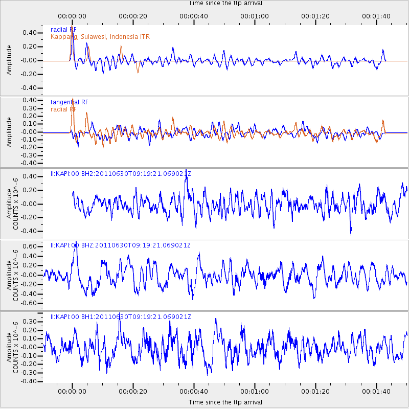
KAPI Kappang, Sulawesi, Indonesia - Earthquake Result Viewer
*The percent match for this event was below the threshold and hence no stack was calculated.
| Earthquake location: |
Tonga Islands Region |
| Earthquake latitude/longitude: |
-23.5/-175.8 |
| Earthquake time(UTC): |
2011/06/30 (181) 09:09:18 GMT |
| Earthquake Depth: |
35 km |
| Earthquake Magnitude: |
5.7 MW, 5.5 MB, 5.5 MS, 5.7 MW |
| Earthquake Catalog/Contributor: |
NEIC PDE/NEIC PDE-M |
|
| Network: |
II Global Seismograph Network (GSN - IRIS/IDA) |
| Station: |
KAPI Kappang, Sulawesi, Indonesia |
| Lat/Lon: |
5.01 S/119.75 E |
| Elevation: |
300 m |
|
| Distance: |
64.6 deg |
| Az: |
275.799 deg |
| Baz: |
113.572 deg |
| Ray Param: |
$rayparam |
*The percent match for this event was below the threshold and hence was not used in the summary stack. |
|
| Radial Match: |
65.34704 % |
| Radial Bump: |
400 |
| Transverse Match: |
72.58563 % |
| Transverse Bump: |
400 |
| SOD ConfigId: |
558545 |
| Insert Time: |
2013-09-18 21:02:28.493 +0000 |
| GWidth: |
2.5 |
| Max Bumps: |
400 |
| Tol: |
0.001 |
|
Signal To Noise
| Channel | StoN | STA | LTA |
| II:KAPI:00:BHZ:20110630T09:19:21.069021Z | 3.5768473 | 3.4572173E-7 | 9.665544E-8 |
| II:KAPI:00:BH1:20110630T09:19:21.069021Z | 1.7012298 | 1.1292832E-7 | 6.63804E-8 |
| II:KAPI:00:BH2:20110630T09:19:21.069021Z | 1.2675925 | 1.2020868E-7 | 9.4832274E-8 |
| Arrivals |
| Ps | |
| PpPs | |
| PsPs/PpSs | |


