You are here: Home > Network List > US - United States National Seismic Network Stations List
> Station HAWA Hanford, Washington, USA > Earthquake Result Viewer
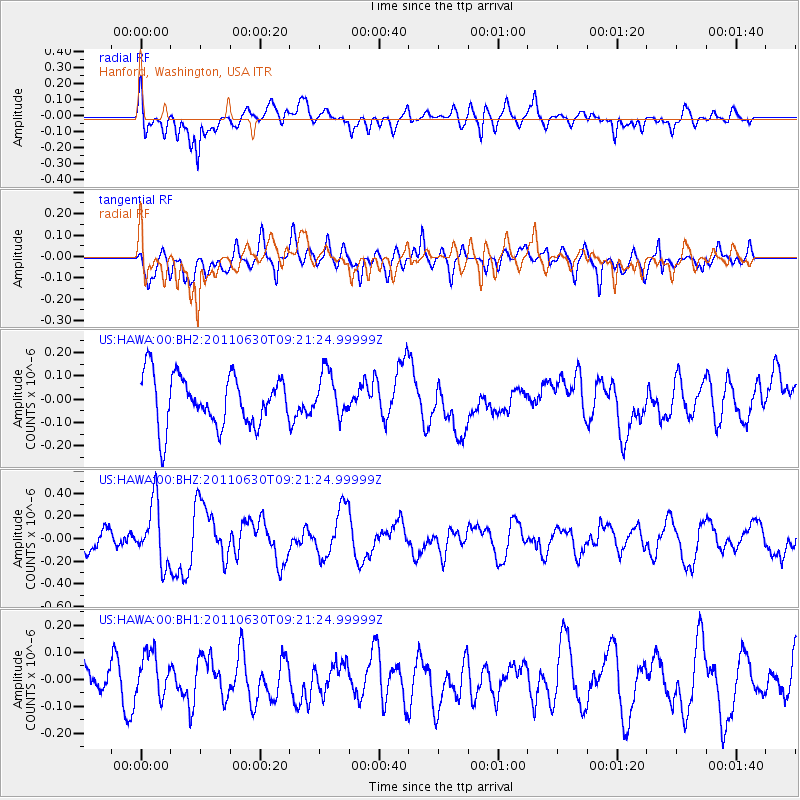
HAWA Hanford, Washington, USA - Earthquake Result Viewer
*The percent match for this event was below the threshold and hence no stack was calculated.
| Earthquake location: |
Tonga Islands Region |
| Earthquake latitude/longitude: |
-23.5/-175.8 |
| Earthquake time(UTC): |
2011/06/30 (181) 09:09:18 GMT |
| Earthquake Depth: |
35 km |
| Earthquake Magnitude: |
5.7 MW, 5.5 MB, 5.5 MS, 5.7 MW |
| Earthquake Catalog/Contributor: |
NEIC PDE/NEIC PDE-M |
|
| Network: |
US United States National Seismic Network |
| Station: |
HAWA Hanford, Washington, USA |
| Lat/Lon: |
46.39 N/119.53 W |
| Elevation: |
364 m |
|
| Distance: |
86.2 deg |
| Az: |
35.253 deg |
| Baz: |
229.939 deg |
| Ray Param: |
$rayparam |
*The percent match for this event was below the threshold and hence was not used in the summary stack. |
|
| Radial Match: |
50.24466 % |
| Radial Bump: |
400 |
| Transverse Match: |
52.810905 % |
| Transverse Bump: |
400 |
| SOD ConfigId: |
558545 |
| Insert Time: |
2013-09-18 21:03:46.349 +0000 |
| GWidth: |
2.5 |
| Max Bumps: |
400 |
| Tol: |
0.001 |
|
Signal To Noise
| Channel | StoN | STA | LTA |
| US:HAWA:00:BHZ:20110630T09:21:24.99999Z | 3.2923825 | 2.6815437E-7 | 8.1446906E-8 |
| US:HAWA:00:BH1:20110630T09:21:24.99999Z | 1.0745237 | 8.288957E-8 | 7.714076E-8 |
| US:HAWA:00:BH2:20110630T09:21:24.99999Z | 0.860215 | 9.3348696E-8 | 1.0851786E-7 |
| Arrivals |
| Ps | |
| PpPs | |
| PsPs/PpSs | |


