You are here: Home > Network List > US - United States National Seismic Network Stations List
> Station MNTX Cornudas Mountains, Texas, USA > Earthquake Result Viewer
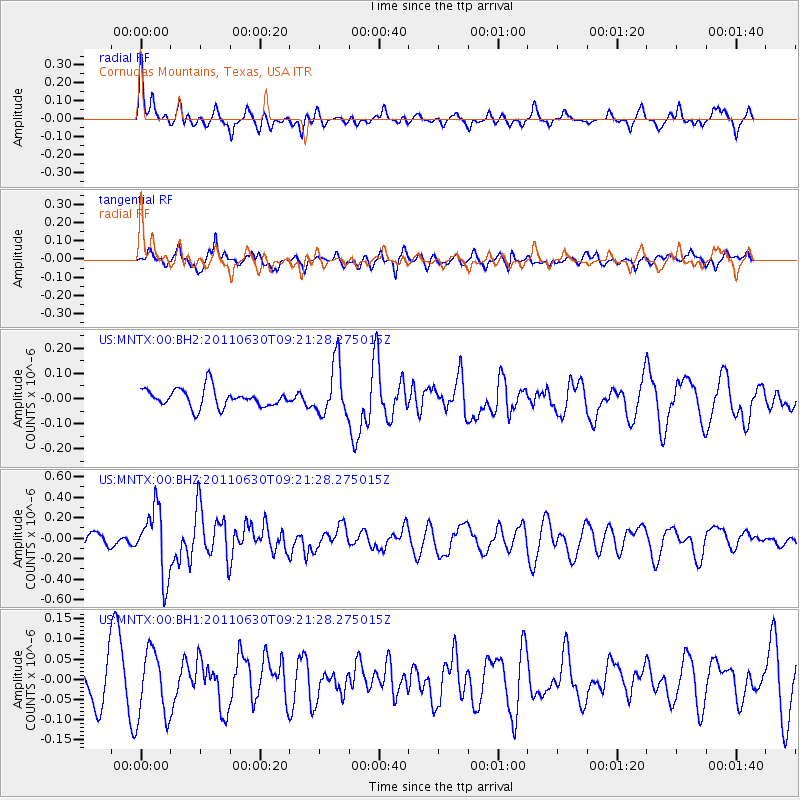
MNTX Cornudas Mountains, Texas, USA - Earthquake Result Viewer
*The percent match for this event was below the threshold and hence no stack was calculated.
| Earthquake location: |
Tonga Islands Region |
| Earthquake latitude/longitude: |
-23.5/-175.8 |
| Earthquake time(UTC): |
2011/06/30 (181) 09:09:18 GMT |
| Earthquake Depth: |
35 km |
| Earthquake Magnitude: |
5.7 MW, 5.5 MB, 5.5 MS, 5.7 MW |
| Earthquake Catalog/Contributor: |
NEIC PDE/NEIC PDE-M |
|
| Network: |
US United States National Seismic Network |
| Station: |
MNTX Cornudas Mountains, Texas, USA |
| Lat/Lon: |
31.70 N/105.38 W |
| Elevation: |
404 m |
|
| Distance: |
86.9 deg |
| Az: |
53.563 deg |
| Baz: |
240.024 deg |
| Ray Param: |
$rayparam |
*The percent match for this event was below the threshold and hence was not used in the summary stack. |
|
| Radial Match: |
59.284206 % |
| Radial Bump: |
356 |
| Transverse Match: |
48.65278 % |
| Transverse Bump: |
400 |
| SOD ConfigId: |
558545 |
| Insert Time: |
2013-09-18 21:03:58.463 +0000 |
| GWidth: |
2.5 |
| Max Bumps: |
400 |
| Tol: |
0.001 |
|
Signal To Noise
| Channel | StoN | STA | LTA |
| US:MNTX:00:BHZ:20110630T09:21:28.275015Z | 4.93397 | 3.2599164E-7 | 6.6070854E-8 |
| US:MNTX:00:BH1:20110630T09:21:28.275015Z | 1.5399446 | 8.325513E-8 | 5.406372E-8 |
| US:MNTX:00:BH2:20110630T09:21:28.275015Z | 2.8702004 | 1.0400376E-7 | 3.6235715E-8 |
| Arrivals |
| Ps | |
| PpPs | |
| PsPs/PpSs | |


