You are here: Home > Network List > CN - Canadian National Seismograph Network Stations List
> Station INK INUVIK, NT, CANADA.ANADA > Earthquake Result Viewer
INK INUVIK, NT, CANADA.ANADA - Earthquake Result Viewer
| Earthquake location: |
Kuril Islands |
| Earthquake latitude/longitude: |
46.0/151.5 |
| Earthquake time(UTC): |
2009/04/07 (097) 04:23:33 GMT |
| Earthquake Depth: |
31 km |
| Earthquake Magnitude: |
6.5 MB, 6.8 MS, 6.9 MW, 6.9 MW |
| Earthquake Catalog/Contributor: |
WHDF/NEIC |
|
| Network: |
CN Canadian National Seismograph Network |
| Station: |
INK INUVIK, NT, CANADA.ANADA |
| Lat/Lon: |
68.31 N/133.52 W |
| Elevation: |
40 m |
|
| Distance: |
42.8 deg |
| Az: |
31.882 deg |
| Baz: |
278.351 deg |
| Ray Param: |
0.07288421 |
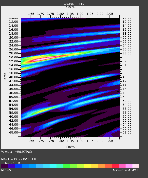
| Estimated Moho Depth: |
30.5 km |
| Estimated Crust Vp/Vs: |
1.71 |
| Assumed Crust Vp: |
6.171 km/s |
| Estimated Crust Vs: |
3.604 km/s |
| Estimated Crust Poisson's Ratio: |
0.24 |
|
| Radial Match: |
96.97963 % |
| Radial Bump: |
245 |
| Transverse Match: |
86.7052 % |
| Transverse Bump: |
400 |
| SOD ConfigId: |
2658 |
| Insert Time: |
2010-02-27 06:07:43.828 +0000 |
| GWidth: |
2.5 |
| Max Bumps: |
400 |
| Tol: |
0.001 |
|

Signal To Noise
| Channel | StoN | STA | LTA |
| CN:INK: :BHN:20090407T04:30:57.600012Z | 64.127144 | 5.917674E-6 | 9.228034E-8 |
| CN:INK: :BHE:20090407T04:30:57.600012Z | 7.2102413 | 6.9295504E-7 | 9.610705E-8 |
| CN:INK: :BHZ:20090407T04:30:57.600012Z | 36.692272 | 3.4981601E-6 | 9.5337796E-8 |
| Arrivals |
| Ps | 3.8 SECOND |
| PpPs | 13 SECOND |
| PsPs/PpSs | 16 SECOND |


