You are here: Home > Network List > US - United States National Seismic Network Stations List
> Station TPNV Topopah Spring, Nevada, USA > Earthquake Result Viewer
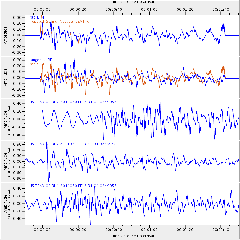
TPNV Topopah Spring, Nevada, USA - Earthquake Result Viewer
*The percent match for this event was below the threshold and hence no stack was calculated.
| Earthquake location: |
South Of Mariana Islands |
| Earthquake latitude/longitude: |
13.1/146.6 |
| Earthquake time(UTC): |
2011/07/01 (182) 13:18:50 GMT |
| Earthquake Depth: |
39 km |
| Earthquake Magnitude: |
5.9 MB, 5.2 MS, 5.6 MW, 5.5 MW |
| Earthquake Catalog/Contributor: |
WHDF/NEIC |
|
| Network: |
US United States National Seismic Network |
| Station: |
TPNV Topopah Spring, Nevada, USA |
| Lat/Lon: |
36.95 N/116.25 W |
| Elevation: |
1600 m |
|
| Distance: |
87.9 deg |
| Az: |
52.689 deg |
| Baz: |
284.703 deg |
| Ray Param: |
$rayparam |
*The percent match for this event was below the threshold and hence was not used in the summary stack. |
|
| Radial Match: |
74.97662 % |
| Radial Bump: |
400 |
| Transverse Match: |
68.40754 % |
| Transverse Bump: |
400 |
| SOD ConfigId: |
558545 |
| Insert Time: |
2013-09-18 21:08:29.905 +0000 |
| GWidth: |
2.5 |
| Max Bumps: |
400 |
| Tol: |
0.001 |
|
Signal To Noise
| Channel | StoN | STA | LTA |
| US:TPNV:00:BHZ:20110701T13:31:04.024995Z | 4.9227023 | 4.7590277E-7 | 9.667511E-8 |
| US:TPNV:00:BH1:20110701T13:31:04.024995Z | 1.2115782 | 9.698776E-8 | 8.005076E-8 |
| US:TPNV:00:BH2:20110701T13:31:04.024995Z | 1.2280134 | 1.6055026E-7 | 1.3073983E-7 |
| Arrivals |
| Ps | |
| PpPs | |
| PsPs/PpSs | |


