You are here: Home > Network List > US - United States National Seismic Network Stations List
> Station DGMT Dagmar, Montana, USA > Earthquake Result Viewer
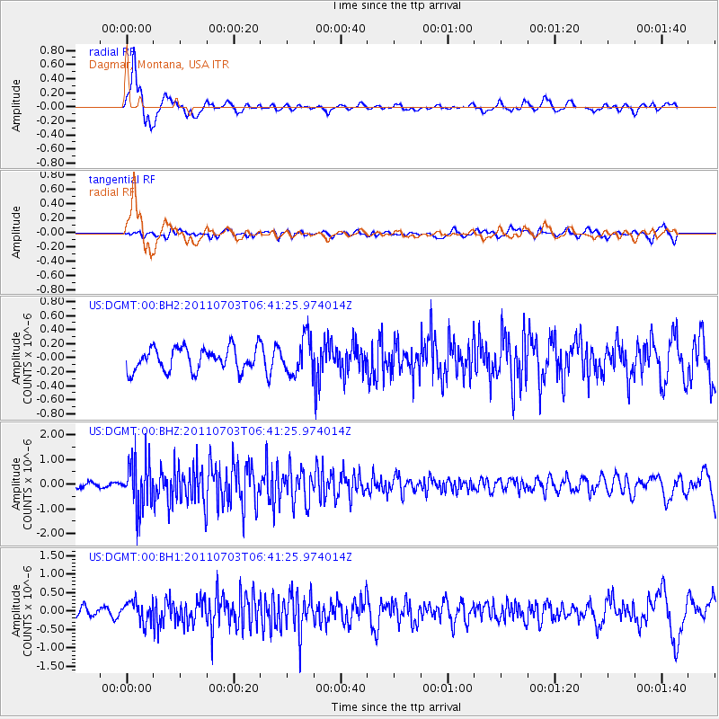
DGMT Dagmar, Montana, USA - Earthquake Result Viewer
*The percent match for this event was below the threshold and hence no stack was calculated.
| Earthquake location: |
Near Coast Of Nicaragua |
| Earthquake latitude/longitude: |
12.4/-87.6 |
| Earthquake time(UTC): |
2011/07/03 (184) 06:34:39 GMT |
| Earthquake Depth: |
59 km |
| Earthquake Magnitude: |
5.5 MB, 5.8 MW, 5.7 MW |
| Earthquake Catalog/Contributor: |
WHDF/NEIC |
|
| Network: |
US United States National Seismic Network |
| Station: |
DGMT Dagmar, Montana, USA |
| Lat/Lon: |
48.47 N/104.20 W |
| Elevation: |
0.0 m |
|
| Distance: |
38.5 deg |
| Az: |
342.212 deg |
| Baz: |
153.356 deg |
| Ray Param: |
$rayparam |
*The percent match for this event was below the threshold and hence was not used in the summary stack. |
|
| Radial Match: |
77.953 % |
| Radial Bump: |
392 |
| Transverse Match: |
44.41556 % |
| Transverse Bump: |
400 |
| SOD ConfigId: |
558545 |
| Insert Time: |
2013-09-18 21:11:28.195 +0000 |
| GWidth: |
2.5 |
| Max Bumps: |
400 |
| Tol: |
0.001 |
|
Signal To Noise
| Channel | StoN | STA | LTA |
| US:DGMT:00:BHZ:20110703T06:41:25.974014Z | 11.427882 | 9.890658E-7 | 8.6548475E-8 |
| US:DGMT:00:BH1:20110703T06:41:25.974014Z | 1.7590315 | 2.9440196E-7 | 1.6736594E-7 |
| US:DGMT:00:BH2:20110703T06:41:25.974014Z | 1.6358523 | 2.6538856E-7 | 1.622326E-7 |
| Arrivals |
| Ps | |
| PpPs | |
| PsPs/PpSs | |


