You are here: Home > Network List > IU - Global Seismograph Network (GSN - IRIS/USGS) Stations List
> Station PMG Port Moresby, New Guinea > Earthquake Result Viewer
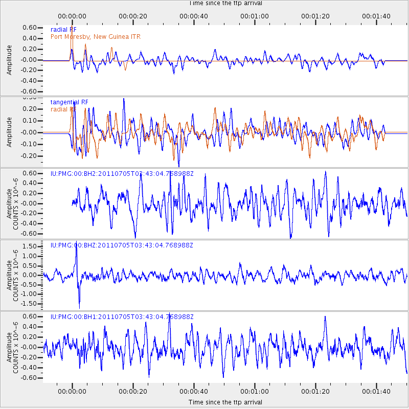
PMG Port Moresby, New Guinea - Earthquake Result Viewer
*The percent match for this event was below the threshold and hence no stack was calculated.
| Earthquake location: |
North Island, New Zealand |
| Earthquake latitude/longitude: |
-38.7/175.8 |
| Earthquake time(UTC): |
2011/07/05 (186) 03:36:25 GMT |
| Earthquake Depth: |
152 km |
| Earthquake Magnitude: |
5.5 MW |
| Earthquake Catalog/Contributor: |
NEIC PDE/NEIC PDE-M |
|
| Network: |
IU Global Seismograph Network (GSN - IRIS/USGS) |
| Station: |
PMG Port Moresby, New Guinea |
| Lat/Lon: |
9.40 S/147.16 E |
| Elevation: |
90 m |
|
| Distance: |
38.8 deg |
| Az: |
311.114 deg |
| Baz: |
143.297 deg |
| Ray Param: |
$rayparam |
*The percent match for this event was below the threshold and hence was not used in the summary stack. |
|
| Radial Match: |
50.230995 % |
| Radial Bump: |
400 |
| Transverse Match: |
57.54873 % |
| Transverse Bump: |
400 |
| SOD ConfigId: |
558545 |
| Insert Time: |
2013-09-18 21:13:28.284 +0000 |
| GWidth: |
2.5 |
| Max Bumps: |
400 |
| Tol: |
0.001 |
|
Signal To Noise
| Channel | StoN | STA | LTA |
| IU:PMG:00:BHZ:20110705T03:43:04.768988Z | 3.6754556 | 6.027656E-7 | 1.6399753E-7 |
| IU:PMG:00:BH1:20110705T03:43:04.768988Z | 0.95566255 | 1.3870145E-7 | 1.4513644E-7 |
| IU:PMG:00:BH2:20110705T03:43:04.768988Z | 1.2044028 | 2.715797E-7 | 2.2548909E-7 |
| Arrivals |
| Ps | |
| PpPs | |
| PsPs/PpSs | |


