You are here: Home > Network List > II - Global Seismograph Network (GSN - IRIS/IDA) Stations List
> Station WRAB Tennant Creek, NT, Australia > Earthquake Result Viewer
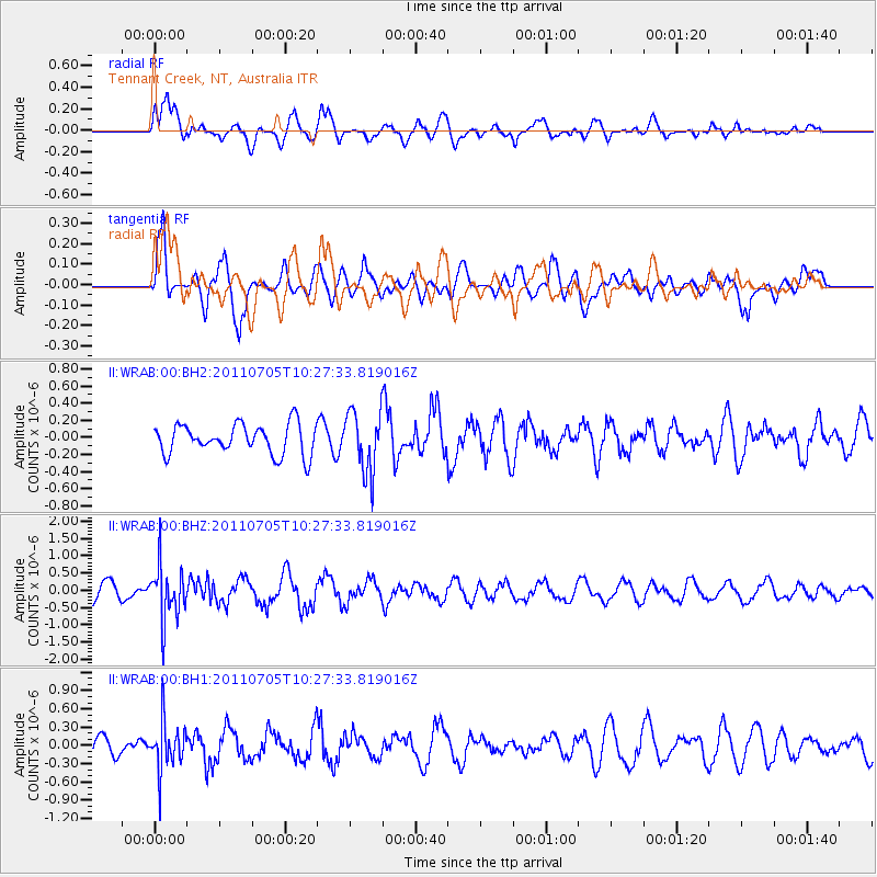
WRAB Tennant Creek, NT, Australia - Earthquake Result Viewer
*The percent match for this event was below the threshold and hence no stack was calculated.
| Earthquake location: |
Near S. Coast Of Western Honshu |
| Earthquake latitude/longitude: |
34.0/135.1 |
| Earthquake time(UTC): |
2011/07/05 (186) 10:18:44 GMT |
| Earthquake Depth: |
16 km |
| Earthquake Magnitude: |
5.5 MB |
| Earthquake Catalog/Contributor: |
NEIC PDE/NEIC PDE-M |
|
| Network: |
II Global Seismograph Network (GSN - IRIS/IDA) |
| Station: |
WRAB Tennant Creek, NT, Australia |
| Lat/Lon: |
19.93 S/134.36 E |
| Elevation: |
366 m |
|
| Distance: |
53.6 deg |
| Az: |
180.906 deg |
| Baz: |
0.8 deg |
| Ray Param: |
$rayparam |
*The percent match for this event was below the threshold and hence was not used in the summary stack. |
|
| Radial Match: |
72.71293 % |
| Radial Bump: |
400 |
| Transverse Match: |
61.242386 % |
| Transverse Bump: |
390 |
| SOD ConfigId: |
558545 |
| Insert Time: |
2013-09-18 21:14:26.860 +0000 |
| GWidth: |
2.5 |
| Max Bumps: |
400 |
| Tol: |
0.001 |
|
Signal To Noise
| Channel | StoN | STA | LTA |
| II:WRAB:00:BHZ:20110705T10:27:33.819016Z | 3.3564823 | 7.740086E-7 | 2.3060112E-7 |
| II:WRAB:00:BH1:20110705T10:27:33.819016Z | 2.8529012 | 3.8220756E-7 | 1.3397153E-7 |
| II:WRAB:00:BH2:20110705T10:27:33.819016Z | 2.0476525 | 3.5735576E-7 | 1.7451973E-7 |
| Arrivals |
| Ps | |
| PpPs | |
| PsPs/PpSs | |


