You are here: Home > Network List > US - United States National Seismic Network Stations List
> Station AGMN Agassiz National Wildlife Refuge, Minnesota, USA > Earthquake Result Viewer
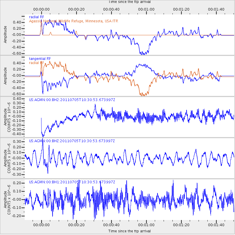
AGMN Agassiz National Wildlife Refuge, Minnesota, USA - Earthquake Result Viewer
*The percent match for this event was below the threshold and hence no stack was calculated.
| Earthquake location: |
Near S. Coast Of Western Honshu |
| Earthquake latitude/longitude: |
34.0/135.1 |
| Earthquake time(UTC): |
2011/07/05 (186) 10:18:44 GMT |
| Earthquake Depth: |
16 km |
| Earthquake Magnitude: |
5.5 MB |
| Earthquake Catalog/Contributor: |
NEIC PDE/NEIC PDE-M |
|
| Network: |
US United States National Seismic Network |
| Station: |
AGMN Agassiz National Wildlife Refuge, Minnesota, USA |
| Lat/Lon: |
48.30 N/95.86 W |
| Elevation: |
351 m |
|
| Distance: |
86.3 deg |
| Az: |
31.333 deg |
| Baz: |
319.679 deg |
| Ray Param: |
$rayparam |
*The percent match for this event was below the threshold and hence was not used in the summary stack. |
|
| Radial Match: |
53.02094 % |
| Radial Bump: |
400 |
| Transverse Match: |
54.97611 % |
| Transverse Bump: |
400 |
| SOD ConfigId: |
558545 |
| Insert Time: |
2013-09-18 21:15:27.767 +0000 |
| GWidth: |
2.5 |
| Max Bumps: |
400 |
| Tol: |
0.001 |
|
Signal To Noise
| Channel | StoN | STA | LTA |
| US:AGMN:00:BHZ:20110705T10:30:53.673997Z | 2.824533 | 1.494516E-7 | 5.2911968E-8 |
| US:AGMN:00:BH1:20110705T10:30:53.673997Z | 1.0868852 | 6.795881E-8 | 6.252621E-8 |
| US:AGMN:00:BH2:20110705T10:30:53.673997Z | 1.6442757 | 2.2559864E-7 | 1.3720243E-7 |
| Arrivals |
| Ps | |
| PpPs | |
| PsPs/PpSs | |


