You are here: Home > Network List > US - United States National Seismic Network Stations List
> Station DGMT Dagmar, Montana, USA > Earthquake Result Viewer
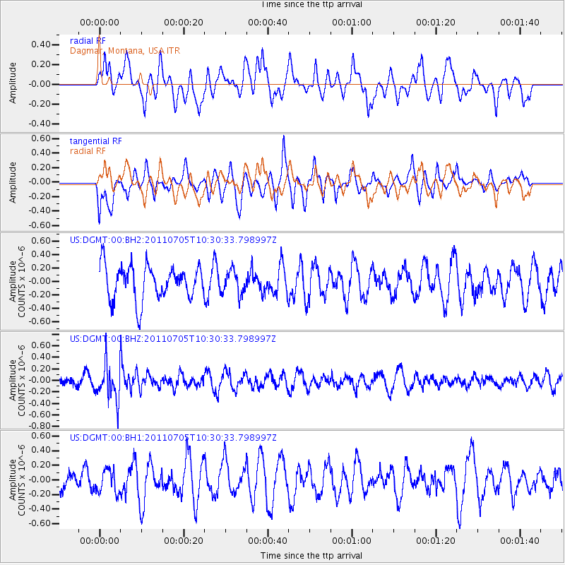
DGMT Dagmar, Montana, USA - Earthquake Result Viewer
*The percent match for this event was below the threshold and hence no stack was calculated.
| Earthquake location: |
Near S. Coast Of Western Honshu |
| Earthquake latitude/longitude: |
34.0/135.1 |
| Earthquake time(UTC): |
2011/07/05 (186) 10:18:44 GMT |
| Earthquake Depth: |
16 km |
| Earthquake Magnitude: |
5.5 MB |
| Earthquake Catalog/Contributor: |
NEIC PDE/NEIC PDE-M |
|
| Network: |
US United States National Seismic Network |
| Station: |
DGMT Dagmar, Montana, USA |
| Lat/Lon: |
48.47 N/104.20 W |
| Elevation: |
0.0 m |
|
| Distance: |
82.3 deg |
| Az: |
35.279 deg |
| Baz: |
313.855 deg |
| Ray Param: |
$rayparam |
*The percent match for this event was below the threshold and hence was not used in the summary stack. |
|
| Radial Match: |
52.237007 % |
| Radial Bump: |
400 |
| Transverse Match: |
42.002827 % |
| Transverse Bump: |
400 |
| SOD ConfigId: |
558545 |
| Insert Time: |
2013-09-18 21:15:39.657 +0000 |
| GWidth: |
2.5 |
| Max Bumps: |
400 |
| Tol: |
0.001 |
|
Signal To Noise
| Channel | StoN | STA | LTA |
| US:DGMT:00:BHZ:20110705T10:30:33.798997Z | 3.6032014 | 3.1299274E-7 | 8.686518E-8 |
| US:DGMT:00:BH1:20110705T10:30:33.798997Z | 0.96010756 | 1.594133E-7 | 1.6603691E-7 |
| US:DGMT:00:BH2:20110705T10:30:33.798997Z | 0.70034343 | 1.7519783E-7 | 2.5015987E-7 |
| Arrivals |
| Ps | |
| PpPs | |
| PsPs/PpSs | |


