You are here: Home > Network List > US - United States National Seismic Network Stations List
> Station MSO Missoula, Montana, USA > Earthquake Result Viewer
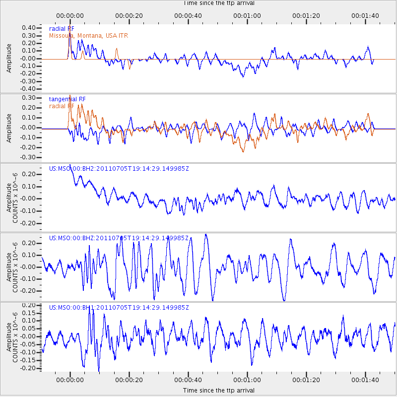
MSO Missoula, Montana, USA - Earthquake Result Viewer
*The percent match for this event was below the threshold and hence no stack was calculated.
| Earthquake location: |
Fiji Islands Region |
| Earthquake latitude/longitude: |
-14.8/-176.0 |
| Earthquake time(UTC): |
2011/07/05 (186) 19:02:38 GMT |
| Earthquake Depth: |
25 km |
| Earthquake Magnitude: |
5.7 MW |
| Earthquake Catalog/Contributor: |
NEIC PDE/NEIC PDE-M |
|
| Network: |
US United States National Seismic Network |
| Station: |
MSO Missoula, Montana, USA |
| Lat/Lon: |
46.83 N/113.94 W |
| Elevation: |
1264 m |
|
| Distance: |
82.7 deg |
| Az: |
37.706 deg |
| Baz: |
239.49 deg |
| Ray Param: |
$rayparam |
*The percent match for this event was below the threshold and hence was not used in the summary stack. |
|
| Radial Match: |
32.16041 % |
| Radial Bump: |
400 |
| Transverse Match: |
54.10431 % |
| Transverse Bump: |
400 |
| SOD ConfigId: |
558545 |
| Insert Time: |
2013-09-18 21:18:26.342 +0000 |
| GWidth: |
2.5 |
| Max Bumps: |
400 |
| Tol: |
0.001 |
|
Signal To Noise
| Channel | StoN | STA | LTA |
| US:MSO:00:BHZ:20110705T19:14:29.149985Z | 1.0195293 | 5.601886E-8 | 5.4945804E-8 |
| US:MSO:00:BH1:20110705T19:14:29.149985Z | 1.6402247 | 1.05732425E-7 | 6.4462164E-8 |
| US:MSO:00:BH2:20110705T19:14:29.149985Z | 1.674027 | 1.2529154E-7 | 7.4844394E-8 |
| Arrivals |
| Ps | |
| PpPs | |
| PsPs/PpSs | |


