You are here: Home > Network List > US - United States National Seismic Network Stations List
> Station MNTX Cornudas Mountains, Texas, USA > Earthquake Result Viewer
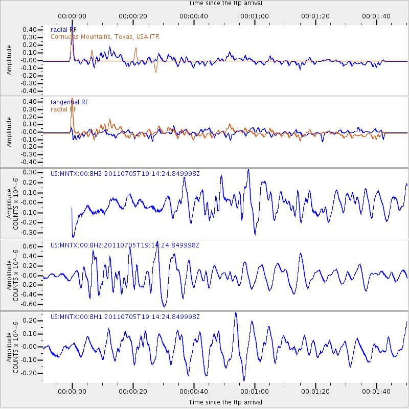
MNTX Cornudas Mountains, Texas, USA - Earthquake Result Viewer
*The percent match for this event was below the threshold and hence no stack was calculated.
| Earthquake location: |
Fiji Islands Region |
| Earthquake latitude/longitude: |
-14.8/-176.0 |
| Earthquake time(UTC): |
2011/07/05 (186) 19:02:38 GMT |
| Earthquake Depth: |
25 km |
| Earthquake Magnitude: |
5.7 MW |
| Earthquake Catalog/Contributor: |
NEIC PDE/NEIC PDE-M |
|
| Network: |
US United States National Seismic Network |
| Station: |
MNTX Cornudas Mountains, Texas, USA |
| Lat/Lon: |
31.70 N/105.38 W |
| Elevation: |
404 m |
|
| Distance: |
81.9 deg |
| Az: |
54.317 deg |
| Baz: |
247.169 deg |
| Ray Param: |
$rayparam |
*The percent match for this event was below the threshold and hence was not used in the summary stack. |
|
| Radial Match: |
61.969738 % |
| Radial Bump: |
400 |
| Transverse Match: |
47.361702 % |
| Transverse Bump: |
400 |
| SOD ConfigId: |
558545 |
| Insert Time: |
2013-09-18 21:18:26.553 +0000 |
| GWidth: |
2.5 |
| Max Bumps: |
400 |
| Tol: |
0.001 |
|
Signal To Noise
| Channel | StoN | STA | LTA |
| US:MNTX:00:BHZ:20110705T19:14:24.849998Z | 1.8629732 | 1.1348253E-7 | 6.0914736E-8 |
| US:MNTX:00:BH1:20110705T19:14:24.849998Z | 1.0453377 | 3.8224638E-8 | 3.656678E-8 |
| US:MNTX:00:BH2:20110705T19:14:24.849998Z | 0.7693306 | 6.5440815E-8 | 8.506202E-8 |
| Arrivals |
| Ps | |
| PpPs | |
| PsPs/PpSs | |


