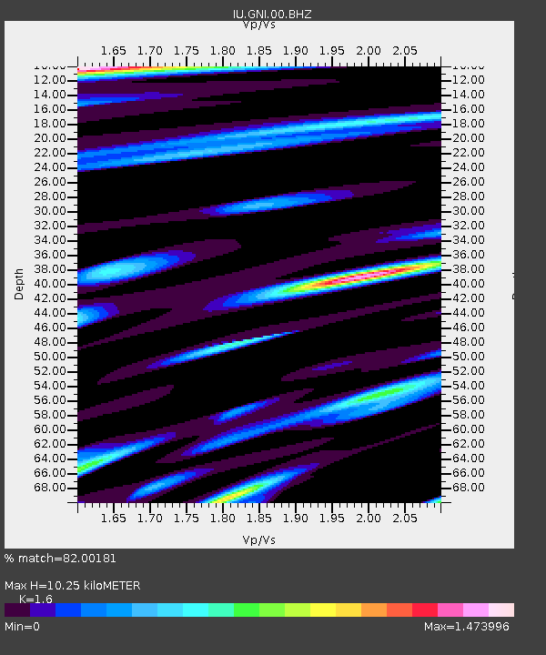
GNI Garni, Armenia - Earthquake Result Viewer
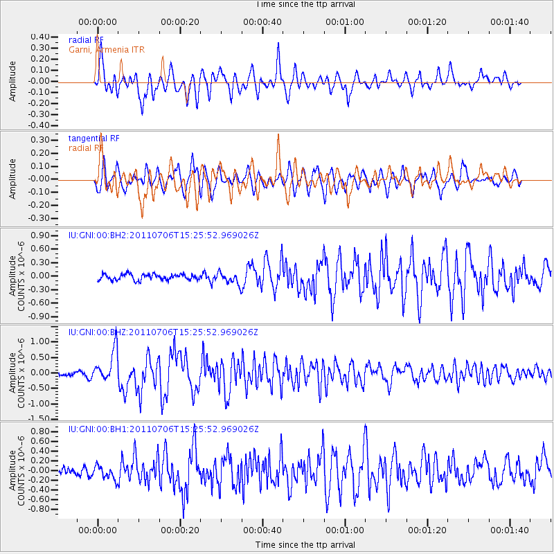
Earthquake location: Near East Coast Of Honshu, Japan
Earthquake latitude/longitude: 36.4/141.6
Earthquake time(UTC): 2011/07/06 (187) 15:14:59 GMT
Earthquake Depth: 10 km
Earthquake Magnitude: 5.7 MW, 5.5 MS, 5.5 MB, 5.7 MW
Earthquake Catalog/Contributor: NEIC PDE/NEIC PDE-M
Network: IU Global Seismograph Network (GSN - IRIS/USGS)
Station: GNI Garni, Armenia
Lat/Lon: 40.15 N/44.74 E
Elevation: 1609 m
Distance: 72.2 deg
Az: 306.955 deg
Baz: 57.288 deg
Ray Param: 0.05379608
Estimated Moho Depth: 10.25 km
Estimated Crust Vp/Vs: 1.60
Assumed Crust Vp: 6.291 km/s
Estimated Crust Vs: 3.932 km/s
Estimated Crust Poisson's Ratio: 0.18
Radial Match: 82.00181 %
Radial Bump: 400
Transverse Match: 78.46906 %
Transverse Bump: 400
SOD ConfigId: 558545
Insert Time: 2013-09-18 21:19:41.979 +0000
GWidth: 2.5
Max Bumps: 400
Tol: 0.001

Signal To Noise

ChannelStoNSTALTA
IU:GNI:00:BHZ:20110706T15:25:52.969026Z6.5817195.4209954E-78.236443E-8
IU:GNI:00:BH1:20110706T15:25:52.969026Z2.03659651.4002494E-76.875438E-8
IU:GNI:00:BH2:20110706T15:25:52.969026Z2.04721021.3316564E-76.504737E-8
Arrivals
Ps1.0 SECOND
PpPs4.1 SECOND
PsPs/PpSs5.1 SECOND