You are here: Home > Network List > KZ - Kazakhstan Network Stations List
> Station KUR21 Cross-array, Kurchatov, Kazakstan > Earthquake Result Viewer
KUR21 Cross-array, Kurchatov, Kazakstan - Earthquake Result Viewer
| Earthquake location: |
Near East Coast Of Honshu, Japan |
| Earthquake latitude/longitude: |
36.4/141.6 |
| Earthquake time(UTC): |
2011/07/06 (187) 15:14:59 GMT |
| Earthquake Depth: |
10 km |
| Earthquake Magnitude: |
5.7 MW, 5.5 MS, 5.5 MB, 5.7 MW |
| Earthquake Catalog/Contributor: |
NEIC PDE/NEIC PDE-M |
|
| Network: |
KZ Kazakhstan Network |
| Station: |
KUR21 Cross-array, Kurchatov, Kazakstan |
| Lat/Lon: |
50.62 N/78.53 E |
| Elevation: |
200 m |
|
| Distance: |
46.5 deg |
| Az: |
308.508 deg |
| Baz: |
82.521 deg |
| Ray Param: |
0.07058159 |
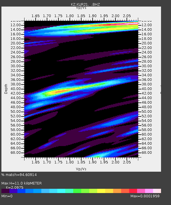
| Estimated Moho Depth: |
11.0 km |
| Estimated Crust Vp/Vs: |
2.10 |
| Assumed Crust Vp: |
6.552 km/s |
| Estimated Crust Vs: |
3.124 km/s |
| Estimated Crust Poisson's Ratio: |
0.35 |
|
| Radial Match: |
94.60914 % |
| Radial Bump: |
400 |
| Transverse Match: |
94.5495 % |
| Transverse Bump: |
386 |
| SOD ConfigId: |
558545 |
| Insert Time: |
2013-09-18 21:20:20.239 +0000 |
| GWidth: |
2.5 |
| Max Bumps: |
400 |
| Tol: |
0.001 |
|

Signal To Noise
| Channel | StoN | STA | LTA |
| KZ:KUR21: :BHZ:20110706T15:22:55.750001Z | 31.569326 | 1.1637894E-6 | 3.6864563E-8 |
| KZ:KUR21: :BH1:20110706T15:22:55.750001Z | 15.220361 | 5.6807227E-7 | 3.732318E-8 |
| KZ:KUR21: :BH2:20110706T15:22:55.750001Z | 3.5129862 | 1.3903043E-7 | 3.957614E-8 |
| Arrivals |
| Ps | 1.9 SECOND |
| PpPs | 4.9 SECOND |
| PsPs/PpSs | 6.9 SECOND |


