You are here: Home > Network List > IU - Global Seismograph Network (GSN - IRIS/USGS) Stations List
> Station PAYG Puerto Ayora, Galapagos Islands > Earthquake Result Viewer
PAYG Puerto Ayora, Galapagos Islands - Earthquake Result Viewer
| Earthquake location: |
Kermadec Islands Region |
| Earthquake latitude/longitude: |
-29.5/-176.3 |
| Earthquake time(UTC): |
2011/07/06 (187) 19:03:18 GMT |
| Earthquake Depth: |
17 km |
| Earthquake Magnitude: |
7.0 MB, 7.8 MS, 7.6 MW, 7.6 MW |
| Earthquake Catalog/Contributor: |
WHDF/NEIC |
|
| Network: |
IU Global Seismograph Network (GSN - IRIS/USGS) |
| Station: |
PAYG Puerto Ayora, Galapagos Islands |
| Lat/Lon: |
0.67 S/90.29 W |
| Elevation: |
270 m |
|
| Distance: |
86.2 deg |
| Az: |
88.647 deg |
| Baz: |
240.604 deg |
| Ray Param: |
0.04418559 |
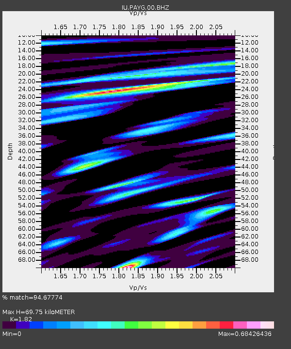
| Estimated Moho Depth: |
69.75 km |
| Estimated Crust Vp/Vs: |
1.82 |
| Assumed Crust Vp: |
4.802 km/s |
| Estimated Crust Vs: |
2.638 km/s |
| Estimated Crust Poisson's Ratio: |
0.28 |
|
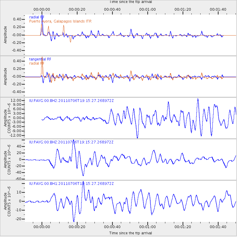
| Radial Match: |
94.67774 % |
| Radial Bump: |
313 |
| Transverse Match: |
84.56279 % |
| Transverse Bump: |
400 |
| SOD ConfigId: |
558545 |
| Insert Time: |
2013-09-18 21:22:57.718 +0000 |
| GWidth: |
2.5 |
| Max Bumps: |
400 |
| Tol: |
0.001 |
|
Signal To Noise
| Channel | StoN | STA | LTA |
| IU:PAYG:00:BHZ:20110706T19:15:27.268972Z | 4.1664557 | 2.3727825E-6 | 5.6949665E-7 |
| IU:PAYG:00:BH1:20110706T19:15:27.268972Z | 1.1202105 | 6.455496E-7 | 5.762752E-7 |
| IU:PAYG:00:BH2:20110706T19:15:27.268972Z | 0.5995752 | 4.611833E-7 | 7.691834E-7 |
| Arrivals |
| Ps | 12 SECOND |
| PpPs | 40 SECOND |
| PsPs/PpSs | 53 SECOND |


