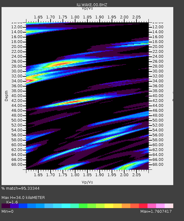
WAKE Wake Island - Earthquake Result Viewer

Earthquake location: Kermadec Islands Region
Earthquake latitude/longitude: -29.5/-176.3
Earthquake time(UTC): 2011/07/06 (187) 19:03:18 GMT
Earthquake Depth: 17 km
Earthquake Magnitude: 7.0 MB, 7.8 MS, 7.6 MW, 7.6 MW
Earthquake Catalog/Contributor: WHDF/NEIC
Network: IU Global Seismograph Network (GSN - IRIS/USGS)
Station: WAKE Wake Island
Lat/Lon: 19.28 N/166.65 E
Elevation: 20 m
Distance: 51.2 deg
Az: 339.246 deg
Baz: 160.919 deg
Ray Param: 0.067524225
Estimated Moho Depth: 34.0 km
Estimated Crust Vp/Vs: 1.60
Assumed Crust Vp: 4.24 km/s
Estimated Crust Vs: 2.65 km/s
Estimated Crust Poisson's Ratio: 0.18
Radial Match: 95.33344 %
Radial Bump: 370
Transverse Match: 87.41201 %
Transverse Bump: 400
SOD ConfigId: 558545
Insert Time: 2013-09-18 21:23:28.212 +0000
GWidth: 2.5
Max Bumps: 400
Tol: 0.001

Signal To Noise

ChannelStoNSTALTA
IU:WAKE:00:BHZ:20110706T19:11:49.918997Z32.6837041.6764492E-55.1293125E-7
IU:WAKE:00:BH1:20110706T19:11:49.918997Z7.56902651.1198391E-51.4795022E-6
IU:WAKE:00:BH2:20110706T19:11:49.918997Z1.68999411.6431313E-69.722704E-7
Arrivals
Ps4.9 SECOND
PpPs20 SECOND
PsPs/PpSs25 SECOND