You are here: Home > Network List > US - United States National Seismic Network Stations List
> Station BOZ Bozeman, Montana, USA > Earthquake Result Viewer
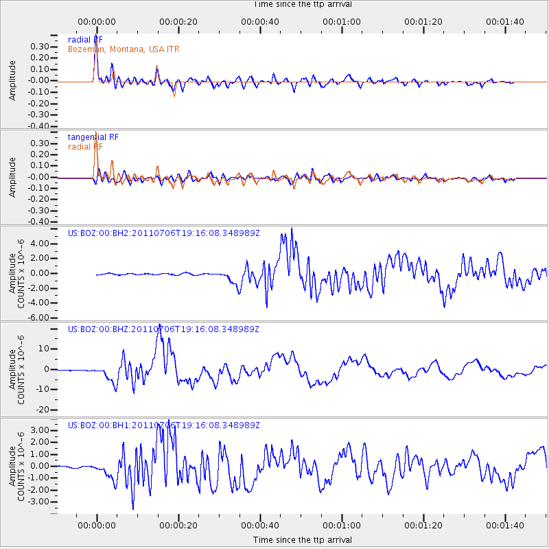
BOZ Bozeman, Montana, USA - Earthquake Result Viewer

| Earthquake location: |
Kermadec Islands Region |
| Earthquake latitude/longitude: |
-29.5/-176.3 |
| Earthquake time(UTC): |
2011/07/06 (187) 19:03:18 GMT |
| Earthquake Depth: |
17 km |
| Earthquake Magnitude: |
7.0 MB, 7.8 MS, 7.6 MW, 7.6 MW |
| Earthquake Catalog/Contributor: |
WHDF/NEIC |
|
| Network: |
US United States National Seismic Network |
| Station: |
BOZ Bozeman, Montana, USA |
| Lat/Lon: |
45.65 N/111.63 W |
| Elevation: |
1589 m |
|
| Distance: |
95.1 deg |
| Az: |
39.549 deg |
| Baz: |
232.281 deg |
| Ray Param: |
0.040874857 |
| Estimated Moho Depth: |
36.75 km |
| Estimated Crust Vp/Vs: |
1.66 |
| Assumed Crust Vp: |
6.35 km/s |
| Estimated Crust Vs: |
3.825 km/s |
| Estimated Crust Poisson's Ratio: |
0.22 |
|
| Radial Match: |
95.55524 % |
| Radial Bump: |
400 |
| Transverse Match: |
87.04962 % |
| Transverse Bump: |
400 |
| SOD ConfigId: |
558545 |
| Insert Time: |
2013-09-18 21:23:40.541 +0000 |
| GWidth: |
2.5 |
| Max Bumps: |
400 |
| Tol: |
0.001 |
|
Signal To Noise
| Channel | StoN | STA | LTA |
| US:BOZ:00:BHZ:20110706T19:16:08.348989Z | 60.96235 | 4.3599475E-6 | 7.151869E-8 |
| US:BOZ:00:BH1:20110706T19:16:08.348989Z | 10.921885 | 7.7584104E-7 | 7.103545E-8 |
| US:BOZ:00:BH2:20110706T19:16:08.348989Z | 10.533419 | 1.070706E-6 | 1.0164848E-7 |
| Arrivals |
| Ps | 3.9 SECOND |
| PpPs | 15 SECOND |
| PsPs/PpSs | 19 SECOND |


