You are here: Home > Network List > US - United States National Seismic Network Stations List
> Station WVOR Wild Horse Valley, Oregon, USA > Earthquake Result Viewer
WVOR Wild Horse Valley, Oregon, USA - Earthquake Result Viewer
| Earthquake location: |
Kermadec Islands Region |
| Earthquake latitude/longitude: |
-29.5/-176.3 |
| Earthquake time(UTC): |
2011/07/06 (187) 19:03:18 GMT |
| Earthquake Depth: |
17 km |
| Earthquake Magnitude: |
7.0 MB, 7.8 MS, 7.6 MW, 7.6 MW |
| Earthquake Catalog/Contributor: |
WHDF/NEIC |
|
| Network: |
US United States National Seismic Network |
| Station: |
WVOR Wild Horse Valley, Oregon, USA |
| Lat/Lon: |
42.43 N/118.64 W |
| Elevation: |
1344 m |
|
| Distance: |
89.1 deg |
| Az: |
38.744 deg |
| Baz: |
227.451 deg |
| Ray Param: |
0.04205286 |
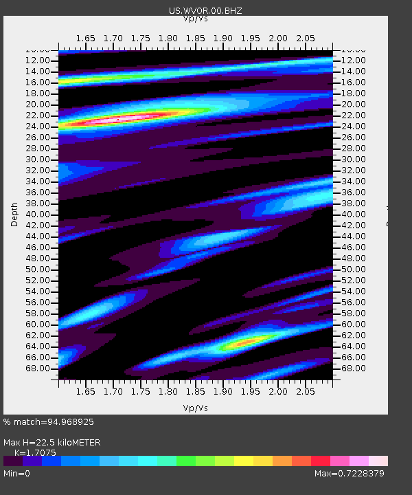
| Estimated Moho Depth: |
22.5 km |
| Estimated Crust Vp/Vs: |
1.71 |
| Assumed Crust Vp: |
6.279 km/s |
| Estimated Crust Vs: |
3.677 km/s |
| Estimated Crust Poisson's Ratio: |
0.24 |
|
| Radial Match: |
94.968925 % |
| Radial Bump: |
361 |
| Transverse Match: |
86.23512 % |
| Transverse Bump: |
400 |
| SOD ConfigId: |
558545 |
| Insert Time: |
2013-09-18 21:24:37.475 +0000 |
| GWidth: |
2.5 |
| Max Bumps: |
400 |
| Tol: |
0.001 |
|
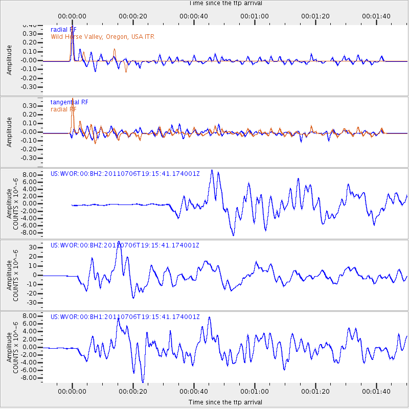
Signal To Noise
| Channel | StoN | STA | LTA |
| US:WVOR:00:BHZ:20110706T19:15:41.174001Z | 74.81025 | 7.234407E-6 | 9.670342E-8 |
| US:WVOR:00:BH1:20110706T19:15:41.174001Z | 20.272293 | 1.4868591E-6 | 7.3344395E-8 |
| US:WVOR:00:BH2:20110706T19:15:41.174001Z | 11.590994 | 1.3654059E-6 | 1.1779887E-7 |
| Arrivals |
| Ps | 2.6 SECOND |
| PpPs | 9.5 SECOND |
| PsPs/PpSs | 12 SECOND |


