You are here: Home > Network List > US - United States National Seismic Network Stations List
> Station AMTX Amarillo, Texas, USA > Earthquake Result Viewer
AMTX Amarillo, Texas, USA - Earthquake Result Viewer
*The percent match for this event was below the threshold and hence no stack was calculated.
| Earthquake location: |
Kermadec Islands Region |
| Earthquake latitude/longitude: |
-29.6/-176.2 |
| Earthquake time(UTC): |
2011/07/06 (187) 20:35:38 GMT |
| Earthquake Depth: |
10 km |
| Earthquake Magnitude: |
5.6 MB |
| Earthquake Catalog/Contributor: |
NEIC PDE/NEIC PDE-M |
|
| Network: |
US United States National Seismic Network |
| Station: |
AMTX Amarillo, Texas, USA |
| Lat/Lon: |
34.53 N/101.41 W |
| Elevation: |
1010 m |
|
| Distance: |
95.1 deg |
| Az: |
53.134 deg |
| Baz: |
237.59 deg |
| Ray Param: |
$rayparam |
*The percent match for this event was below the threshold and hence was not used in the summary stack. |
|
| Radial Match: |
58.597137 % |
| Radial Bump: |
400 |
| Transverse Match: |
59.5041 % |
| Transverse Bump: |
346 |
| SOD ConfigId: |
558545 |
| Insert Time: |
2013-09-18 21:26:11.999 +0000 |
| GWidth: |
2.5 |
| Max Bumps: |
400 |
| Tol: |
0.001 |
|
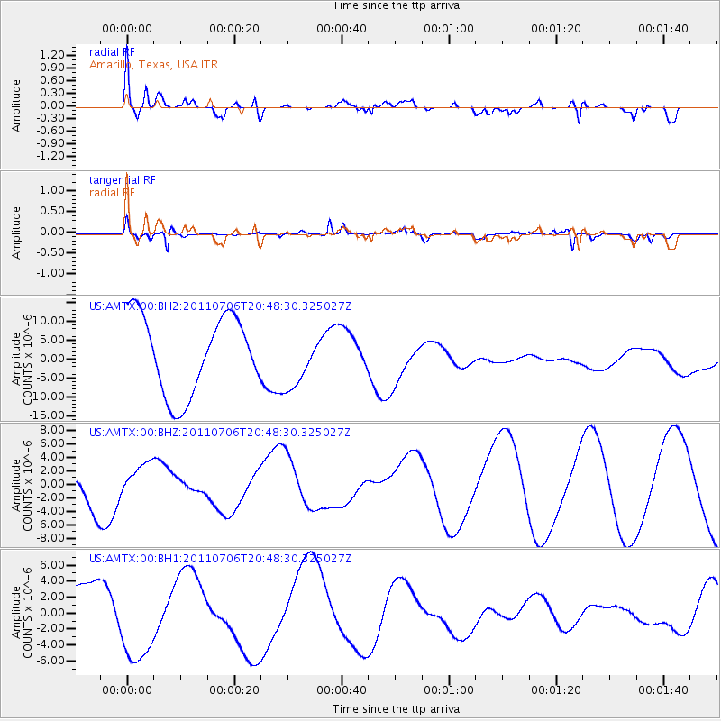
Signal To Noise
| Channel | StoN | STA | LTA |
| US:AMTX:00:BHZ:20110706T20:48:30.325027Z | 0.9173329 | 2.5321872E-6 | 2.7603799E-6 |
| US:AMTX:00:BH1:20110706T20:48:30.325027Z | 1.6591513 | 5.4577686E-6 | 3.289494E-6 |
| US:AMTX:00:BH2:20110706T20:48:30.325027Z | 0.7417029 | 7.5953267E-6 | 1.0240389E-5 |
| Arrivals |
| Ps | |
| PpPs | |
| PsPs/PpSs | |


