You are here: Home > Network List > US - United States National Seismic Network Stations List
> Station EGMT Eagleton, Montana, USA > Earthquake Result Viewer
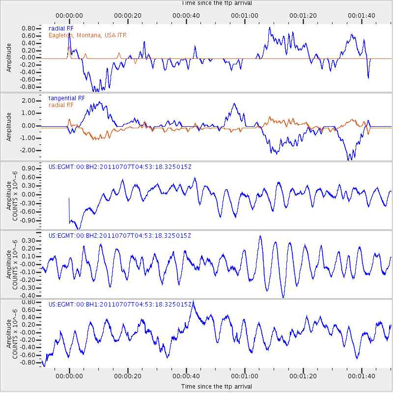
EGMT Eagleton, Montana, USA - Earthquake Result Viewer
*The percent match for this event was below the threshold and hence no stack was calculated.
| Earthquake location: |
Kermadec Islands Region |
| Earthquake latitude/longitude: |
-29.9/-176.3 |
| Earthquake time(UTC): |
2011/07/07 (188) 04:40:15 GMT |
| Earthquake Depth: |
12 km |
| Earthquake Magnitude: |
5.5 MW |
| Earthquake Catalog/Contributor: |
NEIC PDE/NEIC PDE-M |
|
| Network: |
US United States National Seismic Network |
| Station: |
EGMT Eagleton, Montana, USA |
| Lat/Lon: |
48.02 N/109.75 W |
| Elevation: |
1055 m |
|
| Distance: |
97.8 deg |
| Az: |
38.446 deg |
| Baz: |
233.548 deg |
| Ray Param: |
$rayparam |
*The percent match for this event was below the threshold and hence was not used in the summary stack. |
|
| Radial Match: |
31.903307 % |
| Radial Bump: |
400 |
| Transverse Match: |
42.339966 % |
| Transverse Bump: |
400 |
| SOD ConfigId: |
558545 |
| Insert Time: |
2013-09-18 21:28:46.724 +0000 |
| GWidth: |
2.5 |
| Max Bumps: |
400 |
| Tol: |
0.001 |
|
Signal To Noise
| Channel | StoN | STA | LTA |
| US:EGMT:00:BHZ:20110707T04:53:18.325015Z | 1.3122536 | 1.03515774E-7 | 7.888397E-8 |
| US:EGMT:00:BH1:20110707T04:53:18.325015Z | 0.6857703 | 9.653613E-7 | 1.4077037E-6 |
| US:EGMT:00:BH2:20110707T04:53:18.325015Z | 1.0045359 | 4.605368E-7 | 4.584573E-7 |
| Arrivals |
| Ps | |
| PpPs | |
| PsPs/PpSs | |


