You are here: Home > Network List > US - United States National Seismic Network Stations List
> Station DGMT Dagmar, Montana, USA > Earthquake Result Viewer
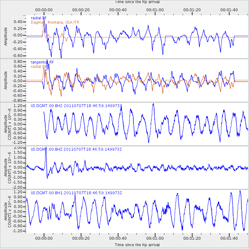
DGMT Dagmar, Montana, USA - Earthquake Result Viewer
*The percent match for this event was below the threshold and hence no stack was calculated.
| Earthquake location: |
Eastern Honshu, Japan |
| Earthquake latitude/longitude: |
37.1/140.9 |
| Earthquake time(UTC): |
2011/07/07 (188) 18:35:40 GMT |
| Earthquake Depth: |
35 km |
| Earthquake Magnitude: |
5.5 MW, 5.6 MW, 5.7 MB |
| Earthquake Catalog/Contributor: |
NEIC PDE/NEIC PDE-M |
|
| Network: |
US United States National Seismic Network |
| Station: |
DGMT Dagmar, Montana, USA |
| Lat/Lon: |
48.47 N/104.20 W |
| Elevation: |
0.0 m |
|
| Distance: |
77.0 deg |
| Az: |
38.261 deg |
| Baz: |
311.952 deg |
| Ray Param: |
$rayparam |
*The percent match for this event was below the threshold and hence was not used in the summary stack. |
|
| Radial Match: |
69.562195 % |
| Radial Bump: |
400 |
| Transverse Match: |
64.25889 % |
| Transverse Bump: |
349 |
| SOD ConfigId: |
558545 |
| Insert Time: |
2013-09-18 21:35:05.680 +0000 |
| GWidth: |
2.5 |
| Max Bumps: |
400 |
| Tol: |
0.001 |
|
Signal To Noise
| Channel | StoN | STA | LTA |
| US:DGMT:00:BHZ:20110707T18:46:59.149973Z | 4.408916 | 6.891181E-7 | 1.5630103E-7 |
| US:DGMT:00:BH1:20110707T18:46:59.149973Z | 0.49352956 | 2.8099072E-7 | 5.693493E-7 |
| US:DGMT:00:BH2:20110707T18:46:59.149973Z | 0.8832936 | 4.2107504E-7 | 4.7671014E-7 |
| Arrivals |
| Ps | |
| PpPs | |
| PsPs/PpSs | |


