You are here: Home > Network List > US - United States National Seismic Network Stations List
> Station HLID Hailey, Idaho, USA > Earthquake Result Viewer
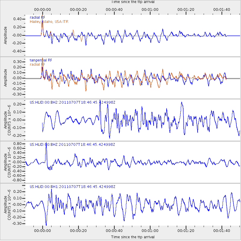
HLID Hailey, Idaho, USA - Earthquake Result Viewer
*The percent match for this event was below the threshold and hence no stack was calculated.
| Earthquake location: |
Eastern Honshu, Japan |
| Earthquake latitude/longitude: |
37.1/140.9 |
| Earthquake time(UTC): |
2011/07/07 (188) 18:35:40 GMT |
| Earthquake Depth: |
35 km |
| Earthquake Magnitude: |
5.5 MW, 5.6 MW, 5.7 MB |
| Earthquake Catalog/Contributor: |
NEIC PDE/NEIC PDE-M |
|
| Network: |
US United States National Seismic Network |
| Station: |
HLID Hailey, Idaho, USA |
| Lat/Lon: |
43.56 N/114.41 W |
| Elevation: |
1772 m |
|
| Distance: |
74.6 deg |
| Az: |
46.817 deg |
| Baz: |
306.705 deg |
| Ray Param: |
$rayparam |
*The percent match for this event was below the threshold and hence was not used in the summary stack. |
|
| Radial Match: |
68.42082 % |
| Radial Bump: |
400 |
| Transverse Match: |
65.82302 % |
| Transverse Bump: |
400 |
| SOD ConfigId: |
558545 |
| Insert Time: |
2013-09-18 21:35:27.336 +0000 |
| GWidth: |
2.5 |
| Max Bumps: |
400 |
| Tol: |
0.001 |
|
Signal To Noise
| Channel | StoN | STA | LTA |
| US:HLID:00:BHZ:20110707T18:46:45.424998Z | 3.655809 | 2.954498E-7 | 8.0816534E-8 |
| US:HLID:00:BH1:20110707T18:46:45.424998Z | 2.5456097 | 1.3335548E-7 | 5.238646E-8 |
| US:HLID:00:BH2:20110707T18:46:45.424998Z | 2.0545826 | 1.1227471E-7 | 5.4645994E-8 |
| Arrivals |
| Ps | |
| PpPs | |
| PsPs/PpSs | |


