You are here: Home > Network List > IU - Global Seismograph Network (GSN - IRIS/USGS) Stations List
> Station MAKZ Makanchi, Kazakhstan > Earthquake Result Viewer
MAKZ Makanchi, Kazakhstan - Earthquake Result Viewer
*The percent match for this event was below the threshold and hence no stack was calculated.
| Earthquake location: |
Minahassa Peninsula, Sulawesi |
| Earthquake latitude/longitude: |
0.1/123.2 |
| Earthquake time(UTC): |
2011/07/08 (189) 05:22:40 GMT |
| Earthquake Depth: |
159 km |
| Earthquake Magnitude: |
5.6 MB, 5.4 MW, 5.3 MW |
| Earthquake Catalog/Contributor: |
WHDF/NEIC |
|
| Network: |
IU Global Seismograph Network (GSN - IRIS/USGS) |
| Station: |
MAKZ Makanchi, Kazakhstan |
| Lat/Lon: |
46.81 N/81.98 E |
| Elevation: |
600 m |
|
| Distance: |
58.8 deg |
| Az: |
328.02 deg |
| Baz: |
129.552 deg |
| Ray Param: |
$rayparam |
*The percent match for this event was below the threshold and hence was not used in the summary stack. |
|
| Radial Match: |
68.973305 % |
| Radial Bump: |
400 |
| Transverse Match: |
55.21024 % |
| Transverse Bump: |
400 |
| SOD ConfigId: |
558545 |
| Insert Time: |
2013-09-18 21:37:43.594 +0000 |
| GWidth: |
2.5 |
| Max Bumps: |
400 |
| Tol: |
0.001 |
|
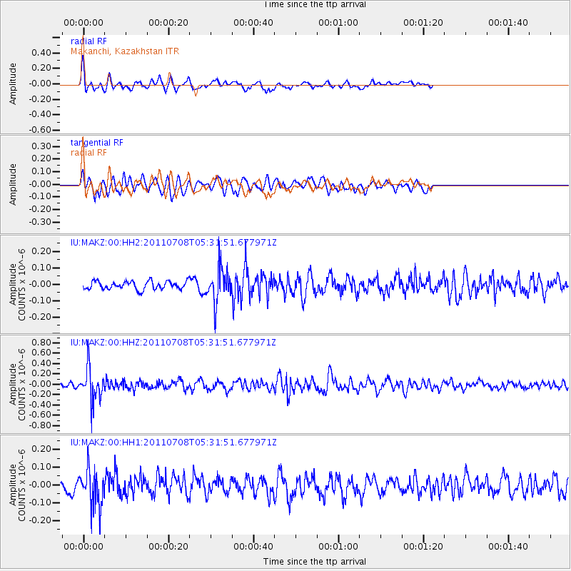
Signal To Noise
| Channel | StoN | STA | LTA |
| IU:MAKZ:00:HHZ:20110708T05:31:51.677971Z | 6.0546227 | 3.246913E-7 | 5.3627012E-8 |
| IU:MAKZ:00:HH1:20110708T05:31:51.677971Z | 3.7539918 | 1.07018785E-7 | 2.8507996E-8 |
| IU:MAKZ:00:HH2:20110708T05:31:51.677971Z | 4.236077 | 1.0372236E-7 | 2.4485475E-8 |
| Arrivals |
| Ps | |
| PpPs | |
| PsPs/PpSs | |


